You are here: Home > Network List > TA - USArray Transportable Network (new EarthScope stations) Stations List
> Station I45A Fountain, MI, USA > Earthquake Result Viewer
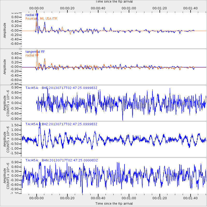
I45A Fountain, MI, USA - Earthquake Result Viewer
*The percent match for this event was below the threshold and hence no stack was calculated.
| Earthquake location: |
Southern Peru |
| Earthquake latitude/longitude: |
-15.7/-71.7 |
| Earthquake time(UTC): |
2013/07/17 (198) 02:37:43 GMT |
| Earthquake Depth: |
7.0 km |
| Earthquake Magnitude: |
6.0 MW, 5.6 MB, 5.8 MS, 5.8 MW |
| Earthquake Catalog/Contributor: |
NEIC PDE/NEIC PDE-W |
|
| Network: |
TA USArray Transportable Network (new EarthScope stations) |
| Station: |
I45A Fountain, MI, USA |
| Lat/Lon: |
44.04 N/86.23 W |
| Elevation: |
215 m |
|
| Distance: |
60.9 deg |
| Az: |
348.073 deg |
| Baz: |
163.975 deg |
| Ray Param: |
$rayparam |
*The percent match for this event was below the threshold and hence was not used in the summary stack. |
|
| Radial Match: |
77.32981 % |
| Radial Bump: |
400 |
| Transverse Match: |
56.75366 % |
| Transverse Bump: |
400 |
| SOD ConfigId: |
512894 |
| Insert Time: |
2013-09-15 20:33:32.930 +0000 |
| GWidth: |
2.5 |
| Max Bumps: |
400 |
| Tol: |
0.001 |
|
Signal To Noise
| Channel | StoN | STA | LTA |
| TA:I45A: :BHZ:20130717T02:47:25.099983Z | 1.7539076 | 7.736517E-7 | 4.4110175E-7 |
| TA:I45A: :BHN:20130717T02:47:25.099983Z | 1.1222093 | 4.6835257E-7 | 4.173487E-7 |
| TA:I45A: :BHE:20130717T02:47:25.099983Z | 1.0547931 | 2.5260042E-7 | 2.3947865E-7 |
| Arrivals |
| Ps | |
| PpPs | |
| PsPs/PpSs | |


