You are here: Home > Network List > TA - USArray Transportable Network (new EarthScope stations) Stations List
> Station I46A Reed City, MI, USA > Earthquake Result Viewer
I46A Reed City, MI, USA - Earthquake Result Viewer
| Earthquake location: |
Southern Peru |
| Earthquake latitude/longitude: |
-15.7/-71.7 |
| Earthquake time(UTC): |
2013/07/17 (198) 02:37:43 GMT |
| Earthquake Depth: |
7.0 km |
| Earthquake Magnitude: |
6.0 MW, 5.6 MB, 5.8 MS, 5.8 MW |
| Earthquake Catalog/Contributor: |
NEIC PDE/NEIC PDE-W |
|
| Network: |
TA USArray Transportable Network (new EarthScope stations) |
| Station: |
I46A Reed City, MI, USA |
| Lat/Lon: |
43.94 N/85.45 W |
| Elevation: |
359 m |
|
| Distance: |
60.6 deg |
| Az: |
348.671 deg |
| Baz: |
164.813 deg |
| Ray Param: |
0.061420314 |
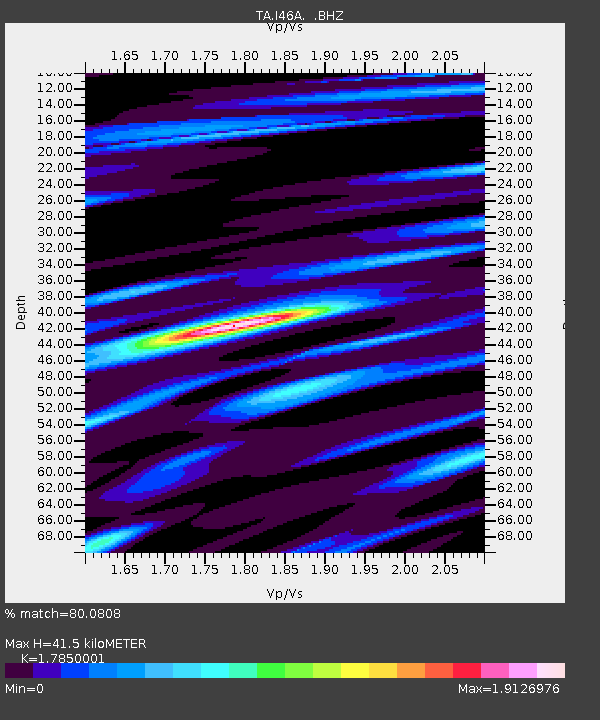
| Estimated Moho Depth: |
41.5 km |
| Estimated Crust Vp/Vs: |
1.79 |
| Assumed Crust Vp: |
6.483 km/s |
| Estimated Crust Vs: |
3.632 km/s |
| Estimated Crust Poisson's Ratio: |
0.27 |
|
| Radial Match: |
80.0808 % |
| Radial Bump: |
400 |
| Transverse Match: |
73.88835 % |
| Transverse Bump: |
400 |
| SOD ConfigId: |
512894 |
| Insert Time: |
2013-09-15 20:33:35.093 +0000 |
| GWidth: |
2.5 |
| Max Bumps: |
400 |
| Tol: |
0.001 |
|

Signal To Noise
| Channel | StoN | STA | LTA |
| TA:I46A: :BHZ:20130717T02:47:23.424019Z | 6.5426784 | 1.4188468E-6 | 2.1686023E-7 |
| TA:I46A: :BHN:20130717T02:47:23.424019Z | 2.4560733 | 7.938382E-7 | 3.2321438E-7 |
| TA:I46A: :BHE:20130717T02:47:23.424019Z | 1.6684619 | 3.7169988E-7 | 2.2277996E-7 |
| Arrivals |
| Ps | 5.3 SECOND |
| PpPs | 17 SECOND |
| PsPs/PpSs | 22 SECOND |


