You are here: Home > Network List > TA - USArray Transportable Network (new EarthScope stations) Stations List
> Station K55A Perry, NY, USA > Earthquake Result Viewer
K55A Perry, NY, USA - Earthquake Result Viewer
| Earthquake location: |
Southern Peru |
| Earthquake latitude/longitude: |
-15.7/-71.7 |
| Earthquake time(UTC): |
2013/07/17 (198) 02:37:43 GMT |
| Earthquake Depth: |
7.0 km |
| Earthquake Magnitude: |
6.0 MW, 5.6 MB, 5.8 MS, 5.8 MW |
| Earthquake Catalog/Contributor: |
NEIC PDE/NEIC PDE-W |
|
| Network: |
TA USArray Transportable Network (new EarthScope stations) |
| Station: |
K55A Perry, NY, USA |
| Lat/Lon: |
42.73 N/78.07 W |
| Elevation: |
482 m |
|
| Distance: |
58.4 deg |
| Az: |
354.526 deg |
| Baz: |
172.836 deg |
| Ray Param: |
0.06288597 |
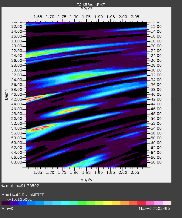
| Estimated Moho Depth: |
42.0 km |
| Estimated Crust Vp/Vs: |
1.61 |
| Assumed Crust Vp: |
6.419 km/s |
| Estimated Crust Vs: |
3.981 km/s |
| Estimated Crust Poisson's Ratio: |
0.19 |
|
| Radial Match: |
91.73592 % |
| Radial Bump: |
330 |
| Transverse Match: |
74.02421 % |
| Transverse Bump: |
400 |
| SOD ConfigId: |
512894 |
| Insert Time: |
2013-09-15 20:35:08.096 +0000 |
| GWidth: |
2.5 |
| Max Bumps: |
400 |
| Tol: |
0.001 |
|
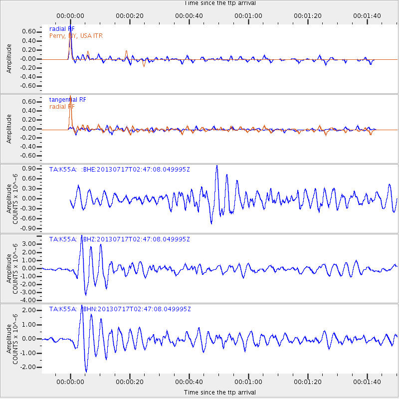
Signal To Noise
| Channel | StoN | STA | LTA |
| TA:K55A: :BHZ:20130717T02:47:08.049995Z | 10.302905 | 1.5620269E-6 | 1.5161034E-7 |
| TA:K55A: :BHN:20130717T02:47:08.049995Z | 7.088304 | 9.541005E-7 | 1.3460209E-7 |
| TA:K55A: :BHE:20130717T02:47:08.049995Z | 0.9962392 | 1.4860416E-7 | 1.4916515E-7 |
| Arrivals |
| Ps | 4.2 SECOND |
| PpPs | 16 SECOND |
| PsPs/PpSs | 20 SECOND |


