You are here: Home > Network List > TA - USArray Transportable Network (new EarthScope stations) Stations List
> Station L50A Kingsville, ON, CAN > Earthquake Result Viewer
L50A Kingsville, ON, CAN - Earthquake Result Viewer
| Earthquake location: |
Southern Peru |
| Earthquake latitude/longitude: |
-15.7/-71.7 |
| Earthquake time(UTC): |
2013/07/17 (198) 02:37:43 GMT |
| Earthquake Depth: |
7.0 km |
| Earthquake Magnitude: |
6.0 MW, 5.6 MB, 5.8 MS, 5.8 MW |
| Earthquake Catalog/Contributor: |
NEIC PDE/NEIC PDE-W |
|
| Network: |
TA USArray Transportable Network (new EarthScope stations) |
| Station: |
L50A Kingsville, ON, CAN |
| Lat/Lon: |
42.04 N/82.81 W |
| Elevation: |
187 m |
|
| Distance: |
58.3 deg |
| Az: |
350.324 deg |
| Baz: |
167.445 deg |
| Ray Param: |
0.06293329 |
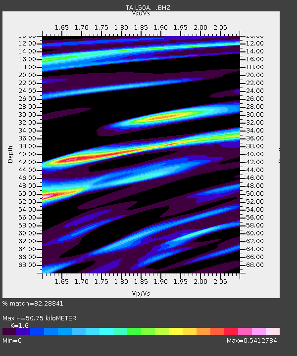
| Estimated Moho Depth: |
50.75 km |
| Estimated Crust Vp/Vs: |
1.60 |
| Assumed Crust Vp: |
6.483 km/s |
| Estimated Crust Vs: |
4.052 km/s |
| Estimated Crust Poisson's Ratio: |
0.18 |
|
| Radial Match: |
82.28841 % |
| Radial Bump: |
362 |
| Transverse Match: |
73.159996 % |
| Transverse Bump: |
400 |
| SOD ConfigId: |
512894 |
| Insert Time: |
2013-09-15 20:35:49.639 +0000 |
| GWidth: |
2.5 |
| Max Bumps: |
400 |
| Tol: |
0.001 |
|
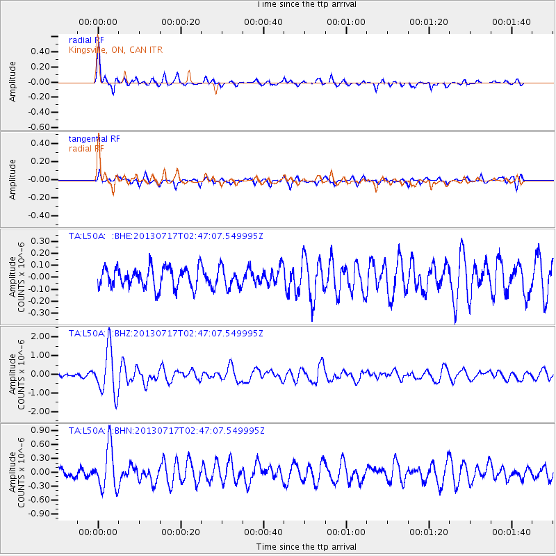
Signal To Noise
| Channel | StoN | STA | LTA |
| TA:L50A: :BHZ:20130717T02:47:07.549995Z | 9.832008 | 1.2455082E-6 | 1.2667891E-7 |
| TA:L50A: :BHN:20130717T02:47:07.549995Z | 4.619874 | 4.7049375E-7 | 1.0184125E-7 |
| TA:L50A: :BHE:20130717T02:47:07.549995Z | 0.9992386 | 8.3181746E-8 | 8.324513E-8 |
| Arrivals |
| Ps | 5.0 SECOND |
| PpPs | 19 SECOND |
| PsPs/PpSs | 24 SECOND |


