You are here: Home > Network List > TA - USArray Transportable Network (new EarthScope stations) Stations List
> Station O48A Farmland, IN, USA > Earthquake Result Viewer
O48A Farmland, IN, USA - Earthquake Result Viewer
*The percent match for this event was below the threshold and hence no stack was calculated.
| Earthquake location: |
Central Peru |
| Earthquake latitude/longitude: |
-14.6/-73.6 |
| Earthquake time(UTC): |
2014/08/24 (236) 23:21:45 GMT |
| Earthquake Depth: |
101 km |
| Earthquake Magnitude: |
6.9 MWW, 6.8 MI, 6.9 MWB |
| Earthquake Catalog/Contributor: |
NEIC PDE/NEIC COMCAT |
|
| Network: |
TA USArray Transportable Network (new EarthScope stations) |
| Station: |
O48A Farmland, IN, USA |
| Lat/Lon: |
40.26 N/85.16 W |
| Elevation: |
300 m |
|
| Distance: |
55.6 deg |
| Az: |
349.274 deg |
| Baz: |
166.382 deg |
| Ray Param: |
$rayparam |
*The percent match for this event was below the threshold and hence was not used in the summary stack. |
|
| Radial Match: |
97.31977 % |
| Radial Bump: |
336 |
| Transverse Match: |
92.45953 % |
| Transverse Bump: |
400 |
| SOD ConfigId: |
3390531 |
| Insert Time: |
2019-04-13 14:35:16.015 +0000 |
| GWidth: |
2.5 |
| Max Bumps: |
400 |
| Tol: |
0.001 |
|
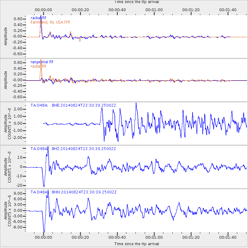
Signal To Noise
| Channel | StoN | STA | LTA |
| TA:O48A: :BHZ:20140824T23:30:39.25002Z | 135.72777 | 1.1588909E-5 | 8.5383476E-8 |
| TA:O48A: :BHN:20140824T23:30:39.25002Z | 63.414707 | 6.2763197E-6 | 9.897263E-8 |
| TA:O48A: :BHE:20140824T23:30:39.25002Z | 14.598886 | 1.1240668E-6 | 7.6996756E-8 |
| Arrivals |
| Ps | |
| PpPs | |
| PsPs/PpSs | |


