You are here: Home > Network List > TA - USArray Transportable Network (new EarthScope stations) Stations List
> Station M53A WI Miller and Sons, Farmdale, OH, USA > Earthquake Result Viewer
M53A WI Miller and Sons, Farmdale, OH, USA - Earthquake Result Viewer
| Earthquake location: |
Southern Peru |
| Earthquake latitude/longitude: |
-15.7/-71.7 |
| Earthquake time(UTC): |
2013/07/17 (198) 02:37:43 GMT |
| Earthquake Depth: |
7.0 km |
| Earthquake Magnitude: |
6.0 MW, 5.6 MB, 5.8 MS, 5.8 MW |
| Earthquake Catalog/Contributor: |
NEIC PDE/NEIC PDE-W |
|
| Network: |
TA USArray Transportable Network (new EarthScope stations) |
| Station: |
M53A WI Miller and Sons, Farmdale, OH, USA |
| Lat/Lon: |
41.44 N/80.68 W |
| Elevation: |
334 m |
|
| Distance: |
57.4 deg |
| Az: |
352.033 deg |
| Baz: |
169.77 deg |
| Ray Param: |
0.06351826 |
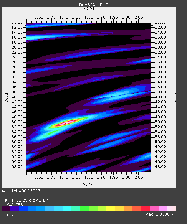
| Estimated Moho Depth: |
50.25 km |
| Estimated Crust Vp/Vs: |
1.75 |
| Assumed Crust Vp: |
6.483 km/s |
| Estimated Crust Vs: |
3.694 km/s |
| Estimated Crust Poisson's Ratio: |
0.26 |
|
| Radial Match: |
88.15987 % |
| Radial Bump: |
400 |
| Transverse Match: |
82.97028 % |
| Transverse Bump: |
376 |
| SOD ConfigId: |
512894 |
| Insert Time: |
2013-09-15 20:36:36.268 +0000 |
| GWidth: |
2.5 |
| Max Bumps: |
400 |
| Tol: |
0.001 |
|

Signal To Noise
| Channel | StoN | STA | LTA |
| TA:M53A: :BHZ:20130717T02:47:01.174995Z | 7.906724 | 1.7258315E-6 | 2.182739E-7 |
| TA:M53A: :BHN:20130717T02:47:01.174995Z | 4.939479 | 8.0188596E-7 | 1.6234222E-7 |
| TA:M53A: :BHE:20130717T02:47:01.174995Z | 1.0099051 | 1.421663E-7 | 1.4077195E-7 |
| Arrivals |
| Ps | 6.2 SECOND |
| PpPs | 20 SECOND |
| PsPs/PpSs | 26 SECOND |


