You are here: Home > Network List > TA - USArray Transportable Network (new EarthScope stations) Stations List
> Station N48A Decatur, IN, USA > Earthquake Result Viewer
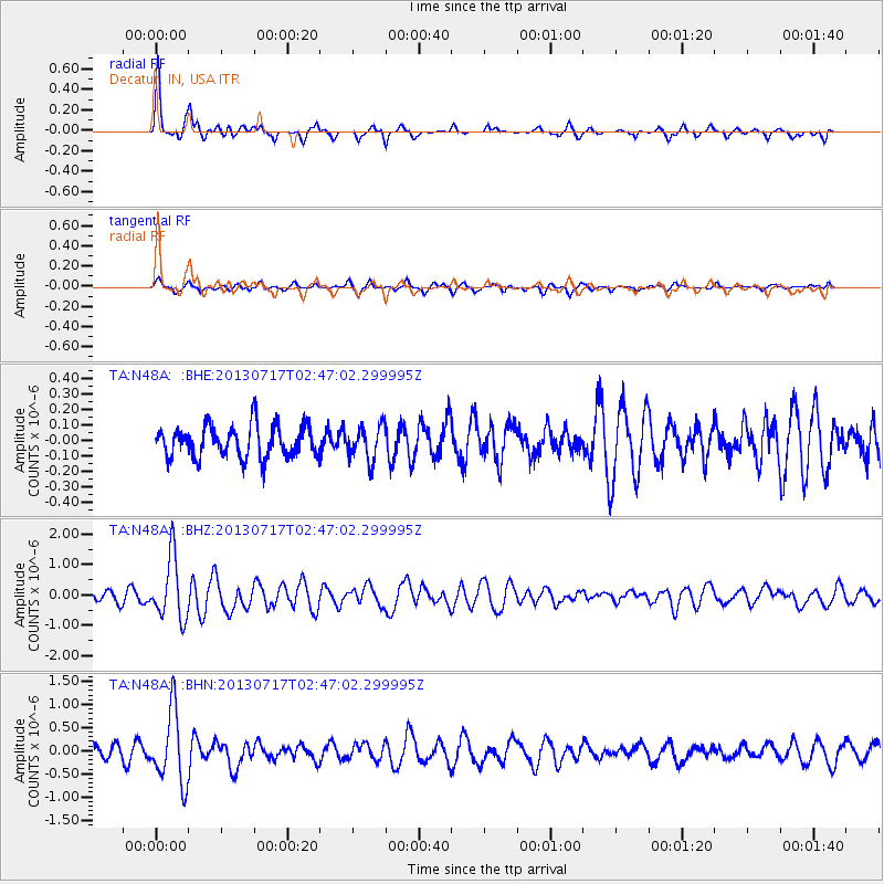
N48A Decatur, IN, USA - Earthquake Result Viewer
*The percent match for this event was below the threshold and hence no stack was calculated.
| Earthquake location: |
Southern Peru |
| Earthquake latitude/longitude: |
-15.7/-71.7 |
| Earthquake time(UTC): |
2013/07/17 (198) 02:37:43 GMT |
| Earthquake Depth: |
7.0 km |
| Earthquake Magnitude: |
6.0 MW, 5.6 MB, 5.8 MS, 5.8 MW |
| Earthquake Catalog/Contributor: |
NEIC PDE/NEIC PDE-W |
|
| Network: |
TA USArray Transportable Network (new EarthScope stations) |
| Station: |
N48A Decatur, IN, USA |
| Lat/Lon: |
40.86 N/85.03 W |
| Elevation: |
250 m |
|
| Distance: |
57.6 deg |
| Az: |
348.08 deg |
| Baz: |
164.791 deg |
| Ray Param: |
$rayparam |
*The percent match for this event was below the threshold and hence was not used in the summary stack. |
|
| Radial Match: |
79.45016 % |
| Radial Bump: |
312 |
| Transverse Match: |
60.89627 % |
| Transverse Bump: |
371 |
| SOD ConfigId: |
512894 |
| Insert Time: |
2013-09-15 20:37:16.924 +0000 |
| GWidth: |
2.5 |
| Max Bumps: |
400 |
| Tol: |
0.001 |
|
Signal To Noise
| Channel | StoN | STA | LTA |
| TA:N48A: :BHZ:20130717T02:47:02.299995Z | 5.163747 | 1.0244855E-6 | 1.9839966E-7 |
| TA:N48A: :BHN:20130717T02:47:02.299995Z | 6.4417663 | 7.766239E-7 | 1.2056071E-7 |
| TA:N48A: :BHE:20130717T02:47:02.299995Z | 1.0639323 | 1.0880182E-7 | 1.0226387E-7 |
| Arrivals |
| Ps | |
| PpPs | |
| PsPs/PpSs | |


