You are here: Home > Network List > TA - USArray Transportable Network (new EarthScope stations) Stations List
> Station O51A Pataskala, OH, USA > Earthquake Result Viewer
O51A Pataskala, OH, USA - Earthquake Result Viewer

| Earthquake location: |
Southern Peru |
| Earthquake latitude/longitude: |
-15.7/-71.7 |
| Earthquake time(UTC): |
2013/07/17 (198) 02:37:43 GMT |
| Earthquake Depth: |
7.0 km |
| Earthquake Magnitude: |
6.0 MW, 5.6 MB, 5.8 MS, 5.8 MW |
| Earthquake Catalog/Contributor: |
NEIC PDE/NEIC PDE-W |
|
| Network: |
TA USArray Transportable Network (new EarthScope stations) |
| Station: |
O51A Pataskala, OH, USA |
| Lat/Lon: |
40.15 N/82.61 W |
| Elevation: |
380 m |
|
| Distance: |
56.4 deg |
| Az: |
350.013 deg |
| Baz: |
167.411 deg |
| Ray Param: |
0.06415428 |
| Estimated Moho Depth: |
55.0 km |
| Estimated Crust Vp/Vs: |
1.65 |
| Assumed Crust Vp: |
6.498 km/s |
| Estimated Crust Vs: |
3.926 km/s |
| Estimated Crust Poisson's Ratio: |
0.21 |
|
| Radial Match: |
85.10657 % |
| Radial Bump: |
378 |
| Transverse Match: |
65.82122 % |
| Transverse Bump: |
400 |
| SOD ConfigId: |
512894 |
| Insert Time: |
2013-09-15 20:38:12.455 +0000 |
| GWidth: |
2.5 |
| Max Bumps: |
400 |
| Tol: |
0.001 |
|
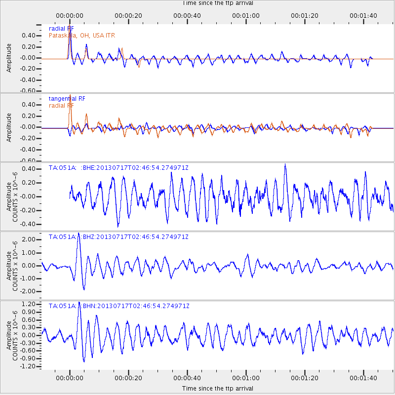
Signal To Noise
| Channel | StoN | STA | LTA |
| TA:O51A: :BHZ:20130717T02:46:54.274971Z | 6.5705123 | 1.1737268E-6 | 1.7863549E-7 |
| TA:O51A: :BHN:20130717T02:46:54.274971Z | 3.1302855 | 5.712378E-7 | 1.8248745E-7 |
| TA:O51A: :BHE:20130717T02:46:54.274971Z | 1.0891266 | 1.7414742E-7 | 1.5989639E-7 |
| Arrivals |
| Ps | 5.9 SECOND |
| PpPs | 21 SECOND |
| PsPs/PpSs | 27 SECOND |


