You are here: Home > Network List > TA - USArray Transportable Network (new EarthScope stations) Stations List
> Station Q49A Aurora, IN, USA > Earthquake Result Viewer
Q49A Aurora, IN, USA - Earthquake Result Viewer
| Earthquake location: |
Southern Peru |
| Earthquake latitude/longitude: |
-15.7/-71.7 |
| Earthquake time(UTC): |
2013/07/17 (198) 02:37:43 GMT |
| Earthquake Depth: |
7.0 km |
| Earthquake Magnitude: |
6.0 MW, 5.6 MB, 5.8 MS, 5.8 MW |
| Earthquake Catalog/Contributor: |
NEIC PDE/NEIC PDE-W |
|
| Network: |
TA USArray Transportable Network (new EarthScope stations) |
| Station: |
Q49A Aurora, IN, USA |
| Lat/Lon: |
39.01 N/84.90 W |
| Elevation: |
264 m |
|
| Distance: |
55.8 deg |
| Az: |
347.612 deg |
| Baz: |
164.618 deg |
| Ray Param: |
0.064596474 |
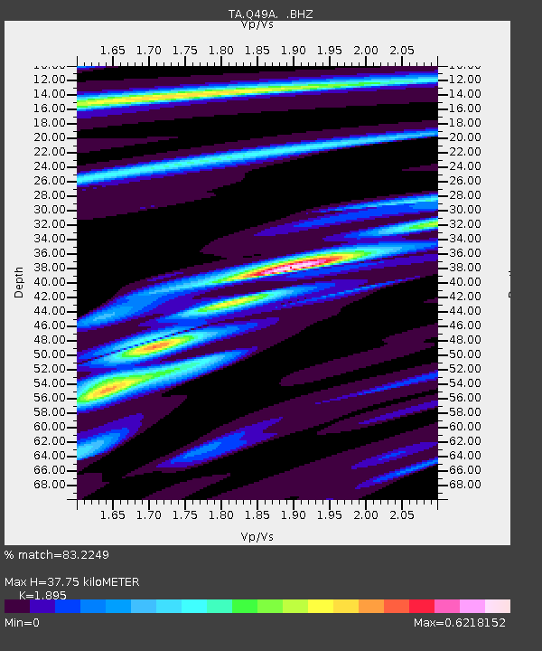
| Estimated Moho Depth: |
37.75 km |
| Estimated Crust Vp/Vs: |
1.89 |
| Assumed Crust Vp: |
6.498 km/s |
| Estimated Crust Vs: |
3.429 km/s |
| Estimated Crust Poisson's Ratio: |
0.31 |
|
| Radial Match: |
83.2249 % |
| Radial Bump: |
341 |
| Transverse Match: |
66.49246 % |
| Transverse Bump: |
379 |
| SOD ConfigId: |
512894 |
| Insert Time: |
2013-09-15 20:39:32.215 +0000 |
| GWidth: |
2.5 |
| Max Bumps: |
400 |
| Tol: |
0.001 |
|

Signal To Noise
| Channel | StoN | STA | LTA |
| TA:Q49A: :BHZ:20130717T02:46:49.424995Z | 7.238889 | 1.1865831E-6 | 1.6391783E-7 |
| TA:Q49A: :BHN:20130717T02:46:49.424995Z | 3.938269 | 5.9043674E-7 | 1.4992291E-7 |
| TA:Q49A: :BHE:20130717T02:46:49.424995Z | 1.0733522 | 7.6060104E-8 | 7.08622E-8 |
| Arrivals |
| Ps | 5.5 SECOND |
| PpPs | 16 SECOND |
| PsPs/PpSs | 21 SECOND |


