You are here: Home > Network List > TA - USArray Transportable Network (new EarthScope stations) Stations List
> Station Q59A Harwood, MD, USA > Earthquake Result Viewer
Q59A Harwood, MD, USA - Earthquake Result Viewer
| Earthquake location: |
Southern Peru |
| Earthquake latitude/longitude: |
-15.7/-71.7 |
| Earthquake time(UTC): |
2013/07/17 (198) 02:37:43 GMT |
| Earthquake Depth: |
7.0 km |
| Earthquake Magnitude: |
6.0 MW, 5.6 MB, 5.8 MS, 5.8 MW |
| Earthquake Catalog/Contributor: |
NEIC PDE/NEIC PDE-W |
|
| Network: |
TA USArray Transportable Network (new EarthScope stations) |
| Station: |
Q59A Harwood, MD, USA |
| Lat/Lon: |
38.86 N/76.65 W |
| Elevation: |
34 m |
|
| Distance: |
54.4 deg |
| Az: |
355.283 deg |
| Baz: |
174.176 deg |
| Ray Param: |
0.06546063 |
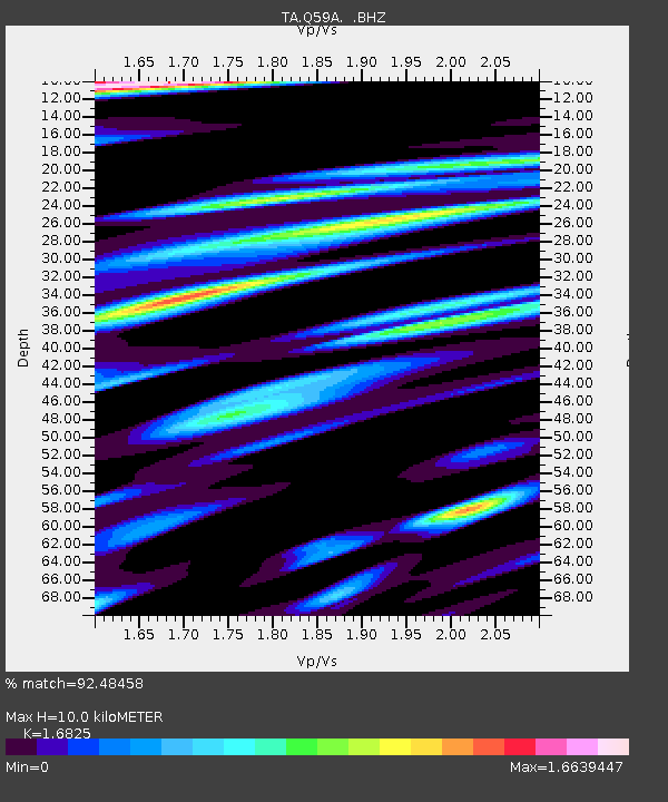
| Estimated Moho Depth: |
10.0 km |
| Estimated Crust Vp/Vs: |
1.68 |
| Assumed Crust Vp: |
6.419 km/s |
| Estimated Crust Vs: |
3.815 km/s |
| Estimated Crust Poisson's Ratio: |
0.23 |
|
| Radial Match: |
92.48458 % |
| Radial Bump: |
350 |
| Transverse Match: |
86.351326 % |
| Transverse Bump: |
356 |
| SOD ConfigId: |
512894 |
| Insert Time: |
2013-09-15 20:39:58.952 +0000 |
| GWidth: |
2.5 |
| Max Bumps: |
400 |
| Tol: |
0.001 |
|

Signal To Noise
| Channel | StoN | STA | LTA |
| TA:Q59A: :BHZ:20130717T02:46:39.899971Z | 8.2201605 | 1.1666064E-6 | 1.4192014E-7 |
| TA:Q59A: :BHN:20130717T02:46:39.899971Z | 3.1018744 | 9.2161577E-7 | 2.9711578E-7 |
| TA:Q59A: :BHE:20130717T02:46:39.899971Z | 1.192935 | 4.0989153E-7 | 3.435992E-7 |
| Arrivals |
| Ps | 1.1 SECOND |
| PpPs | 4.0 SECOND |
| PsPs/PpSs | 5.1 SECOND |


