You are here: Home > Network List > TA - USArray Transportable Network (new EarthScope stations) Stations List
> Station R48A Northridge Ranch, Floyd Knobs, IN, USA > Earthquake Result Viewer
R48A Northridge Ranch, Floyd Knobs, IN, USA - Earthquake Result Viewer

| Earthquake location: |
Southern Peru |
| Earthquake latitude/longitude: |
-15.7/-71.7 |
| Earthquake time(UTC): |
2013/07/17 (198) 02:37:43 GMT |
| Earthquake Depth: |
7.0 km |
| Earthquake Magnitude: |
6.0 MW, 5.6 MB, 5.8 MS, 5.8 MW |
| Earthquake Catalog/Contributor: |
NEIC PDE/NEIC PDE-W |
|
| Network: |
TA USArray Transportable Network (new EarthScope stations) |
| Station: |
R48A Northridge Ranch, Floyd Knobs, IN, USA |
| Lat/Lon: |
38.40 N/85.87 W |
| Elevation: |
243 m |
|
| Distance: |
55.4 deg |
| Az: |
346.52 deg |
| Baz: |
163.393 deg |
| Ray Param: |
0.06483761 |
| Estimated Moho Depth: |
64.25 km |
| Estimated Crust Vp/Vs: |
1.60 |
| Assumed Crust Vp: |
6.498 km/s |
| Estimated Crust Vs: |
4.061 km/s |
| Estimated Crust Poisson's Ratio: |
0.18 |
|
| Radial Match: |
91.846375 % |
| Radial Bump: |
374 |
| Transverse Match: |
62.673763 % |
| Transverse Bump: |
400 |
| SOD ConfigId: |
512894 |
| Insert Time: |
2013-09-15 20:40:10.453 +0000 |
| GWidth: |
2.5 |
| Max Bumps: |
400 |
| Tol: |
0.001 |
|
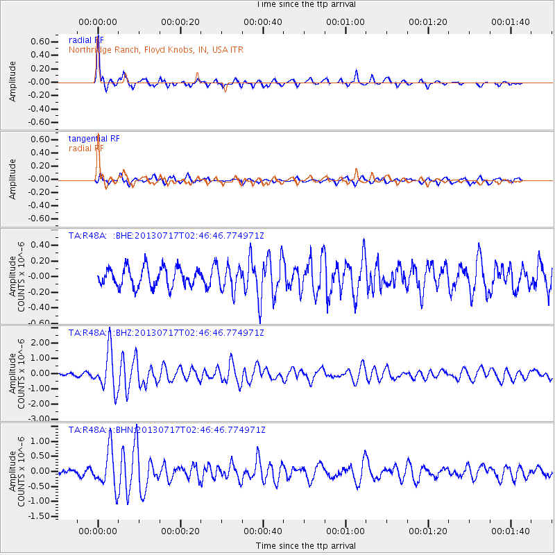
Signal To Noise
| Channel | StoN | STA | LTA |
| TA:R48A: :BHZ:20130717T02:46:46.774971Z | 18.553474 | 1.3334306E-6 | 7.186959E-8 |
| TA:R48A: :BHN:20130717T02:46:46.774971Z | 7.5317273 | 6.631364E-7 | 8.804573E-8 |
| TA:R48A: :BHE:20130717T02:46:46.774971Z | 1.2606645 | 1.5243084E-7 | 1.209131E-7 |
| Arrivals |
| Ps | 6.3 SECOND |
| PpPs | 24 SECOND |
| PsPs/PpSs | 31 SECOND |


