You are here: Home > Network List > TA - USArray Transportable Network (new EarthScope stations) Stations List
> Station R49A Shelbyville, KY, USA > Earthquake Result Viewer
R49A Shelbyville, KY, USA - Earthquake Result Viewer
| Earthquake location: |
Southern Peru |
| Earthquake latitude/longitude: |
-15.7/-71.7 |
| Earthquake time(UTC): |
2013/07/17 (198) 02:37:43 GMT |
| Earthquake Depth: |
7.0 km |
| Earthquake Magnitude: |
6.0 MW, 5.6 MB, 5.8 MS, 5.8 MW |
| Earthquake Catalog/Contributor: |
NEIC PDE/NEIC PDE-W |
|
| Network: |
TA USArray Transportable Network (new EarthScope stations) |
| Station: |
R49A Shelbyville, KY, USA |
| Lat/Lon: |
38.29 N/85.17 W |
| Elevation: |
251 m |
|
| Distance: |
55.1 deg |
| Az: |
347.127 deg |
| Baz: |
164.171 deg |
| Ray Param: |
0.06500917 |
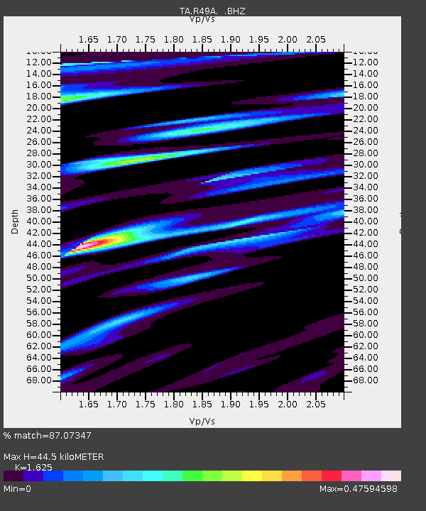
| Estimated Moho Depth: |
44.5 km |
| Estimated Crust Vp/Vs: |
1.62 |
| Assumed Crust Vp: |
6.498 km/s |
| Estimated Crust Vs: |
3.998 km/s |
| Estimated Crust Poisson's Ratio: |
0.20 |
|
| Radial Match: |
87.07347 % |
| Radial Bump: |
400 |
| Transverse Match: |
78.10032 % |
| Transverse Bump: |
379 |
| SOD ConfigId: |
512894 |
| Insert Time: |
2013-09-15 20:40:15.098 +0000 |
| GWidth: |
2.5 |
| Max Bumps: |
400 |
| Tol: |
0.001 |
|
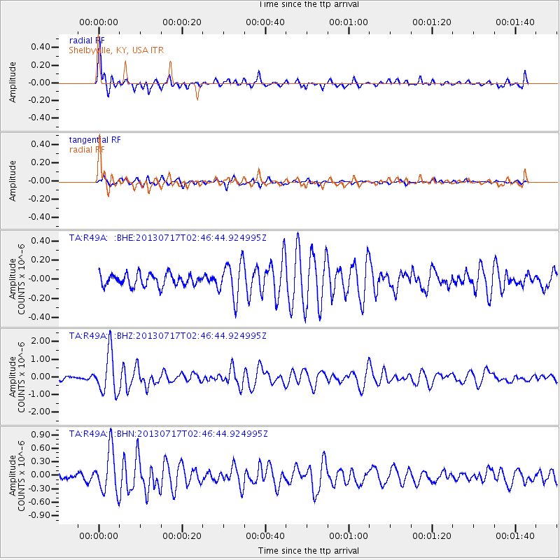
Signal To Noise
| Channel | StoN | STA | LTA |
| TA:R49A: :BHZ:20130717T02:46:44.924995Z | 6.4375567 | 1.1796144E-6 | 1.8323945E-7 |
| TA:R49A: :BHN:20130717T02:46:44.924995Z | 5.3900757 | 4.849073E-7 | 8.996298E-8 |
| TA:R49A: :BHE:20130717T02:46:44.924995Z | 3.1220162 | 1.928801E-7 | 6.178062E-8 |
| Arrivals |
| Ps | 4.5 SECOND |
| PpPs | 17 SECOND |
| PsPs/PpSs | 21 SECOND |


