You are here: Home > Network List > TA - USArray Transportable Network (new EarthScope stations) Stations List
> Station R57A Stanardsville, VA, USA > Earthquake Result Viewer
R57A Stanardsville, VA, USA - Earthquake Result Viewer
| Earthquake location: |
Southern Peru |
| Earthquake latitude/longitude: |
-15.7/-71.7 |
| Earthquake time(UTC): |
2013/07/17 (198) 02:37:43 GMT |
| Earthquake Depth: |
7.0 km |
| Earthquake Magnitude: |
6.0 MW, 5.6 MB, 5.8 MS, 5.8 MW |
| Earthquake Catalog/Contributor: |
NEIC PDE/NEIC PDE-W |
|
| Network: |
TA USArray Transportable Network (new EarthScope stations) |
| Station: |
R57A Stanardsville, VA, USA |
| Lat/Lon: |
38.30 N/78.52 W |
| Elevation: |
230 m |
|
| Distance: |
54.0 deg |
| Az: |
353.407 deg |
| Baz: |
171.919 deg |
| Ray Param: |
0.065701336 |
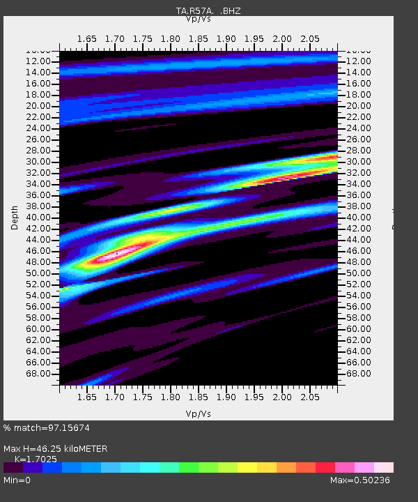
| Estimated Moho Depth: |
46.25 km |
| Estimated Crust Vp/Vs: |
1.70 |
| Assumed Crust Vp: |
6.159 km/s |
| Estimated Crust Vs: |
3.617 km/s |
| Estimated Crust Poisson's Ratio: |
0.24 |
|
| Radial Match: |
97.15674 % |
| Radial Bump: |
254 |
| Transverse Match: |
86.70213 % |
| Transverse Bump: |
400 |
| SOD ConfigId: |
512894 |
| Insert Time: |
2013-09-15 20:40:37.910 +0000 |
| GWidth: |
2.5 |
| Max Bumps: |
400 |
| Tol: |
0.001 |
|

Signal To Noise
| Channel | StoN | STA | LTA |
| TA:R57A: :BHZ:20130717T02:46:37.099983Z | 18.156113 | 1.7706537E-6 | 9.752383E-8 |
| TA:R57A: :BHN:20130717T02:46:37.099983Z | 19.528524 | 9.1297153E-7 | 4.675067E-8 |
| TA:R57A: :BHE:20130717T02:46:37.099983Z | 0.9968228 | 1.14658654E-7 | 1.1502411E-7 |
| Arrivals |
| Ps | 5.6 SECOND |
| PpPs | 19 SECOND |
| PsPs/PpSs | 25 SECOND |


