You are here: Home > Network List > XD14 - Illuminating the architecture of the greater Mount St. Helens magmatic systems f Stations List
> Station MG03 "Mount St Helens, WA" > Earthquake Result Viewer
MG03 "Mount St Helens, WA" - Earthquake Result Viewer
| Earthquake location: |
Central Peru |
| Earthquake latitude/longitude: |
-14.6/-73.6 |
| Earthquake time(UTC): |
2014/08/24 (236) 23:21:45 GMT |
| Earthquake Depth: |
101 km |
| Earthquake Magnitude: |
6.9 MWW, 6.8 MI, 6.9 MWB |
| Earthquake Catalog/Contributor: |
NEIC PDE/NEIC COMCAT |
|
| Network: |
XD Illuminating the architecture of the greater Mount St. Helens magmatic systems f |
| Station: |
MG03 "Mount St Helens, WA" |
| Lat/Lon: |
46.34 N/122.48 W |
| Elevation: |
638 m |
|
| Distance: |
74.9 deg |
| Az: |
327.266 deg |
| Baz: |
130.917 deg |
| Ray Param: |
0.051791582 |
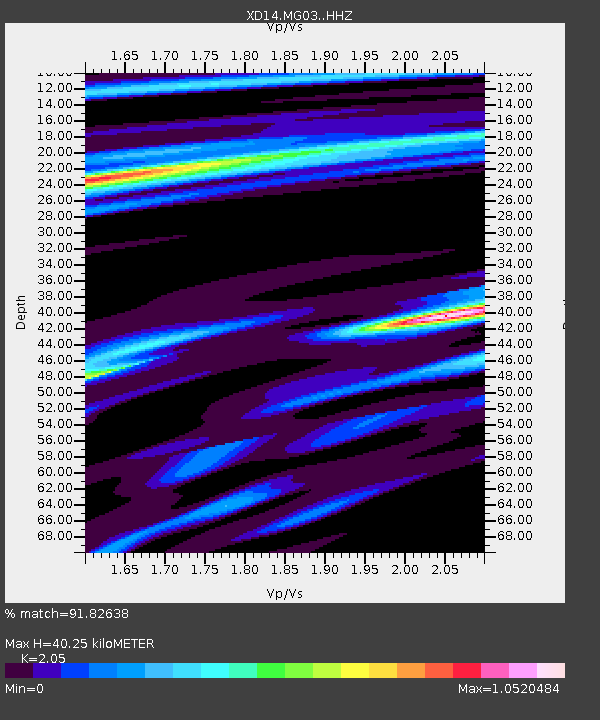
| Estimated Moho Depth: |
40.25 km |
| Estimated Crust Vp/Vs: |
2.05 |
| Assumed Crust Vp: |
6.566 km/s |
| Estimated Crust Vs: |
3.203 km/s |
| Estimated Crust Poisson's Ratio: |
0.34 |
|
| Radial Match: |
91.82638 % |
| Radial Bump: |
400 |
| Transverse Match: |
83.61543 % |
| Transverse Bump: |
400 |
| SOD ConfigId: |
3390531 |
| Insert Time: |
2019-04-13 14:36:52.411 +0000 |
| GWidth: |
2.5 |
| Max Bumps: |
400 |
| Tol: |
0.001 |
|

Signal To Noise
| Channel | StoN | STA | LTA |
| XD:MG03: :HHZ:20140824T23:32:43.860005Z | 64.903786 | 7.929952E-6 | 1.2218011E-7 |
| XD:MG03: :HHN:20140824T23:32:43.860005Z | 10.282975 | 1.5843668E-6 | 1.540767E-7 |
| XD:MG03: :HHE:20140824T23:32:43.860005Z | 17.865067 | 1.734932E-6 | 9.71131E-8 |
| Arrivals |
| Ps | 6.6 SECOND |
| PpPs | 18 SECOND |
| PsPs/PpSs | 25 SECOND |


