You are here: Home > Network List > TA - USArray Transportable Network (new EarthScope stations) Stations List
> Station T52A Hallie, KY, USA > Earthquake Result Viewer
T52A Hallie, KY, USA - Earthquake Result Viewer
| Earthquake location: |
Southern Peru |
| Earthquake latitude/longitude: |
-15.7/-71.7 |
| Earthquake time(UTC): |
2013/07/17 (198) 02:37:43 GMT |
| Earthquake Depth: |
7.0 km |
| Earthquake Magnitude: |
6.0 MW, 5.6 MB, 5.8 MS, 5.8 MW |
| Earthquake Catalog/Contributor: |
NEIC PDE/NEIC PDE-W |
|
| Network: |
TA USArray Transportable Network (new EarthScope stations) |
| Station: |
T52A Hallie, KY, USA |
| Lat/Lon: |
37.11 N/82.99 W |
| Elevation: |
436 m |
|
| Distance: |
53.5 deg |
| Az: |
348.823 deg |
| Baz: |
166.492 deg |
| Ray Param: |
0.066038795 |
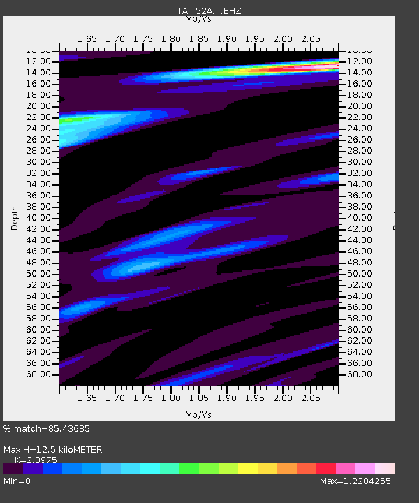
| Estimated Moho Depth: |
12.5 km |
| Estimated Crust Vp/Vs: |
2.10 |
| Assumed Crust Vp: |
6.476 km/s |
| Estimated Crust Vs: |
3.087 km/s |
| Estimated Crust Poisson's Ratio: |
0.35 |
|
| Radial Match: |
85.43685 % |
| Radial Bump: |
400 |
| Transverse Match: |
74.84705 % |
| Transverse Bump: |
400 |
| SOD ConfigId: |
512894 |
| Insert Time: |
2013-09-15 20:42:23.611 +0000 |
| GWidth: |
2.5 |
| Max Bumps: |
400 |
| Tol: |
0.001 |
|
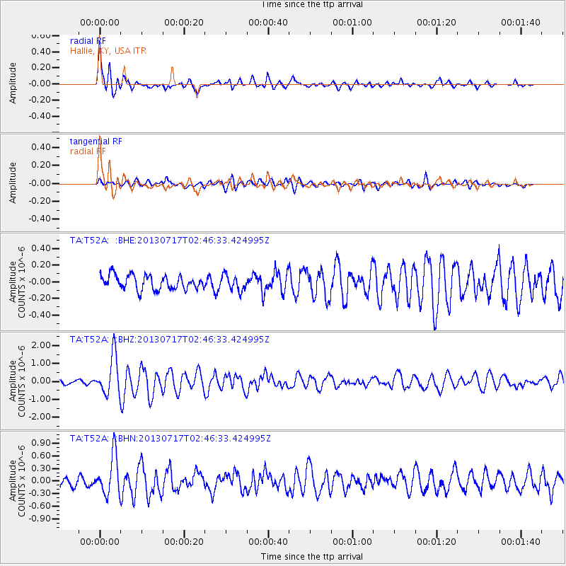
Signal To Noise
| Channel | StoN | STA | LTA |
| TA:T52A: :BHZ:20130717T02:46:33.424995Z | 12.48494 | 1.0991482E-6 | 8.8037936E-8 |
| TA:T52A: :BHN:20130717T02:46:33.424995Z | 6.709722 | 4.8174917E-7 | 7.1798674E-8 |
| TA:T52A: :BHE:20130717T02:46:33.424995Z | 1.123418 | 9.614723E-8 | 8.558456E-8 |
| Arrivals |
| Ps | 2.2 SECOND |
| PpPs | 5.7 SECOND |
| PsPs/PpSs | 7.9 SECOND |


