You are here: Home > Network List > TA - USArray Transportable Network (new EarthScope stations) Stations List
> Station T58A Grand View Acres, VA, USA > Earthquake Result Viewer
T58A Grand View Acres, VA, USA - Earthquake Result Viewer
| Earthquake location: |
Southern Peru |
| Earthquake latitude/longitude: |
-15.7/-71.7 |
| Earthquake time(UTC): |
2013/07/17 (198) 02:37:43 GMT |
| Earthquake Depth: |
7.0 km |
| Earthquake Magnitude: |
6.0 MW, 5.6 MB, 5.8 MS, 5.8 MW |
| Earthquake Catalog/Contributor: |
NEIC PDE/NEIC PDE-W |
|
| Network: |
TA USArray Transportable Network (new EarthScope stations) |
| Station: |
T58A Grand View Acres, VA, USA |
| Lat/Lon: |
36.95 N/78.53 W |
| Elevation: |
167 m |
|
| Distance: |
52.7 deg |
| Az: |
353.158 deg |
| Baz: |
171.764 deg |
| Ray Param: |
0.066593155 |
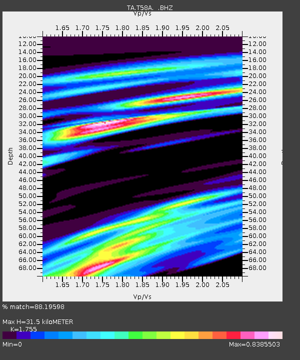
| Estimated Moho Depth: |
31.5 km |
| Estimated Crust Vp/Vs: |
1.75 |
| Assumed Crust Vp: |
6.419 km/s |
| Estimated Crust Vs: |
3.658 km/s |
| Estimated Crust Poisson's Ratio: |
0.26 |
|
| Radial Match: |
88.19598 % |
| Radial Bump: |
400 |
| Transverse Match: |
36.11293 % |
| Transverse Bump: |
400 |
| SOD ConfigId: |
512894 |
| Insert Time: |
2013-09-15 20:42:45.201 +0000 |
| GWidth: |
2.5 |
| Max Bumps: |
400 |
| Tol: |
0.001 |
|

Signal To Noise
| Channel | StoN | STA | LTA |
| TA:T58A: :BHZ:20130717T02:46:27.299995Z | 15.758639 | 1.9059686E-6 | 1.2094753E-7 |
| TA:T58A: :BHN:20130717T02:46:27.299995Z | 5.660726 | 1.0880458E-6 | 1.9220957E-7 |
| TA:T58A: :BHE:20130717T02:46:27.299995Z | 0.68451244 | 3.5487892E-7 | 5.184404E-7 |
| Arrivals |
| Ps | 3.9 SECOND |
| PpPs | 13 SECOND |
| PsPs/PpSs | 17 SECOND |


