You are here: Home > Network List > TA - USArray Transportable Network (new EarthScope stations) Stations List
> Station T57A Hurt, VA, USA > Earthquake Result Viewer
T57A Hurt, VA, USA - Earthquake Result Viewer
| Earthquake location: |
Southern Peru |
| Earthquake latitude/longitude: |
-15.7/-71.7 |
| Earthquake time(UTC): |
2013/07/17 (198) 02:37:43 GMT |
| Earthquake Depth: |
7.0 km |
| Earthquake Magnitude: |
6.0 MW, 5.6 MB, 5.8 MS, 5.8 MW |
| Earthquake Catalog/Contributor: |
NEIC PDE/NEIC PDE-W |
|
| Network: |
TA USArray Transportable Network (new EarthScope stations) |
| Station: |
T57A Hurt, VA, USA |
| Lat/Lon: |
37.00 N/79.25 W |
| Elevation: |
230 m |
|
| Distance: |
52.8 deg |
| Az: |
352.453 deg |
| Baz: |
170.906 deg |
| Ray Param: |
0.06650298 |
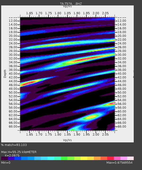
| Estimated Moho Depth: |
55.25 km |
| Estimated Crust Vp/Vs: |
2.10 |
| Assumed Crust Vp: |
6.419 km/s |
| Estimated Crust Vs: |
3.06 km/s |
| Estimated Crust Poisson's Ratio: |
0.35 |
|
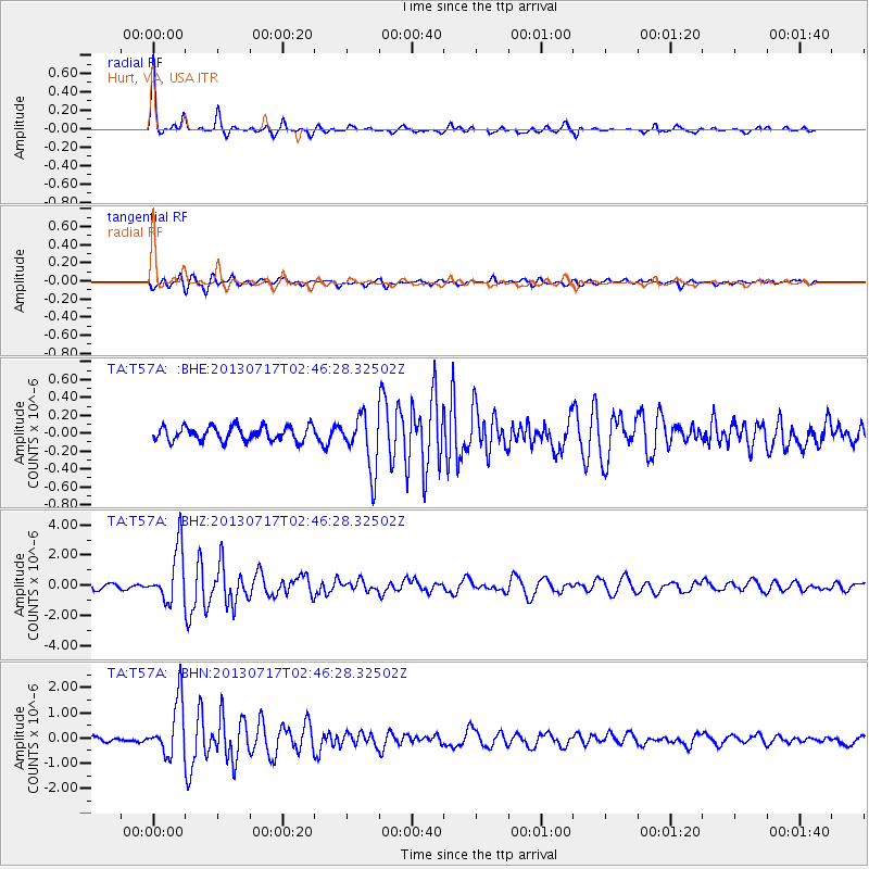
| Radial Match: |
93.103 % |
| Radial Bump: |
279 |
| Transverse Match: |
84.60459 % |
| Transverse Bump: |
400 |
| SOD ConfigId: |
512894 |
| Insert Time: |
2013-09-15 20:42:45.375 +0000 |
| GWidth: |
2.5 |
| Max Bumps: |
400 |
| Tol: |
0.001 |
|
Signal To Noise
| Channel | StoN | STA | LTA |
| TA:T57A: :BHZ:20130717T02:46:28.32502Z | 8.771401 | 1.7702854E-6 | 2.0182469E-7 |
| TA:T57A: :BHN:20130717T02:46:28.32502Z | 11.596439 | 1.0743419E-6 | 9.264411E-8 |
| TA:T57A: :BHE:20130717T02:46:28.32502Z | 3.8576143 | 3.0974033E-7 | 8.029323E-8 |
| Arrivals |
| Ps | 9.9 SECOND |
| PpPs | 25 SECOND |
| PsPs/PpSs | 35 SECOND |


