You are here: Home > Network List > TA - USArray Transportable Network (new EarthScope stations) Stations List
> Station U40A Yellville, AR, USA > Earthquake Result Viewer
U40A Yellville, AR, USA - Earthquake Result Viewer
| Earthquake location: |
Southern Peru |
| Earthquake latitude/longitude: |
-15.7/-71.7 |
| Earthquake time(UTC): |
2013/07/17 (198) 02:37:43 GMT |
| Earthquake Depth: |
7.0 km |
| Earthquake Magnitude: |
6.0 MW, 5.6 MB, 5.8 MS, 5.8 MW |
| Earthquake Catalog/Contributor: |
NEIC PDE/NEIC PDE-W |
|
| Network: |
TA USArray Transportable Network (new EarthScope stations) |
| Station: |
U40A Yellville, AR, USA |
| Lat/Lon: |
36.36 N/92.85 W |
| Elevation: |
374 m |
|
| Distance: |
55.4 deg |
| Az: |
339.325 deg |
| Baz: |
155.081 deg |
| Ray Param: |
0.0647942 |
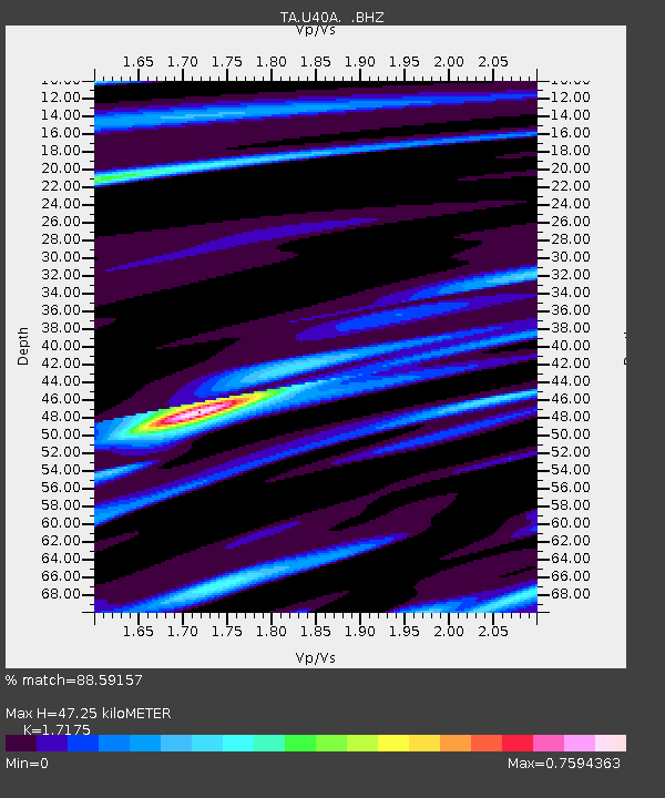
| Estimated Moho Depth: |
47.25 km |
| Estimated Crust Vp/Vs: |
1.72 |
| Assumed Crust Vp: |
6.53 km/s |
| Estimated Crust Vs: |
3.802 km/s |
| Estimated Crust Poisson's Ratio: |
0.24 |
|
| Radial Match: |
88.59157 % |
| Radial Bump: |
323 |
| Transverse Match: |
73.14192 % |
| Transverse Bump: |
400 |
| SOD ConfigId: |
512894 |
| Insert Time: |
2013-09-15 20:43:08.811 +0000 |
| GWidth: |
2.5 |
| Max Bumps: |
400 |
| Tol: |
0.001 |
|
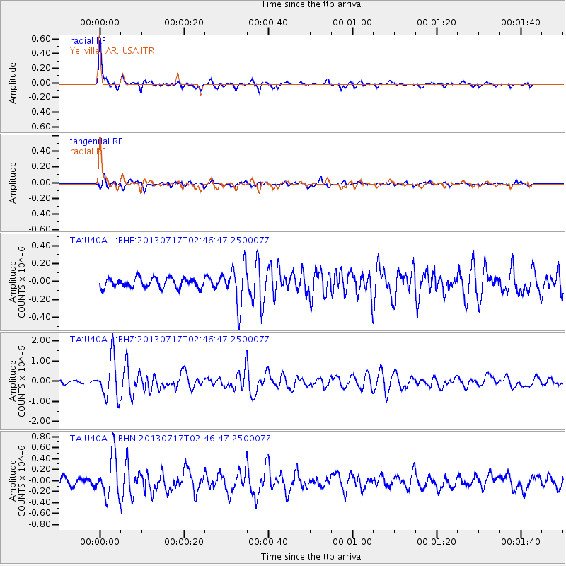
Signal To Noise
| Channel | StoN | STA | LTA |
| TA:U40A: :BHZ:20130717T02:46:47.250007Z | 10.745623 | 1.0043952E-6 | 9.347018E-8 |
| TA:U40A: :BHN:20130717T02:46:47.250007Z | 4.087653 | 3.8499167E-7 | 9.418404E-8 |
| TA:U40A: :BHE:20130717T02:46:47.250007Z | 4.114041 | 2.2115636E-7 | 5.3756477E-8 |
| Arrivals |
| Ps | 5.5 SECOND |
| PpPs | 19 SECOND |
| PsPs/PpSs | 24 SECOND |


