You are here: Home > Network List > TA - USArray Transportable Network (new EarthScope stations) Stations List
> Station U47A Clarksville, TN, USA > Earthquake Result Viewer
U47A Clarksville, TN, USA - Earthquake Result Viewer
| Earthquake location: |
Southern Peru |
| Earthquake latitude/longitude: |
-15.7/-71.7 |
| Earthquake time(UTC): |
2013/07/17 (198) 02:37:43 GMT |
| Earthquake Depth: |
7.0 km |
| Earthquake Magnitude: |
6.0 MW, 5.6 MB, 5.8 MS, 5.8 MW |
| Earthquake Catalog/Contributor: |
NEIC PDE/NEIC PDE-W |
|
| Network: |
TA USArray Transportable Network (new EarthScope stations) |
| Station: |
U47A Clarksville, TN, USA |
| Lat/Lon: |
36.44 N/87.29 W |
| Elevation: |
145 m |
|
| Distance: |
53.9 deg |
| Az: |
344.475 deg |
| Baz: |
161.35 deg |
| Ray Param: |
0.06582516 |
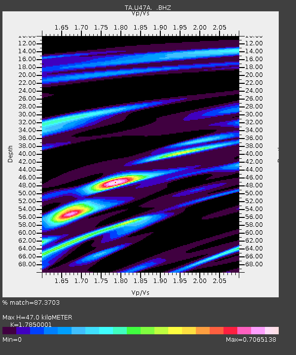
| Estimated Moho Depth: |
47.0 km |
| Estimated Crust Vp/Vs: |
1.79 |
| Assumed Crust Vp: |
6.444 km/s |
| Estimated Crust Vs: |
3.61 km/s |
| Estimated Crust Poisson's Ratio: |
0.27 |
|
| Radial Match: |
87.3703 % |
| Radial Bump: |
302 |
| Transverse Match: |
72.82952 % |
| Transverse Bump: |
400 |
| SOD ConfigId: |
512894 |
| Insert Time: |
2013-09-15 20:43:15.315 +0000 |
| GWidth: |
2.5 |
| Max Bumps: |
400 |
| Tol: |
0.001 |
|

Signal To Noise
| Channel | StoN | STA | LTA |
| TA:U47A: :BHZ:20130717T02:46:35.750007Z | 6.262885 | 9.4369244E-7 | 1.5068014E-7 |
| TA:U47A: :BHN:20130717T02:46:35.750007Z | 4.0564594 | 3.7378754E-7 | 9.214626E-8 |
| TA:U47A: :BHE:20130717T02:46:35.750007Z | 2.2384489 | 1.3643711E-7 | 6.0951635E-8 |
| Arrivals |
| Ps | 6.0 SECOND |
| PpPs | 19 SECOND |
| PsPs/PpSs | 25 SECOND |


