You are here: Home > Network List > TA - USArray Transportable Network (new EarthScope stations) Stations List
> Station U57A Blanch, NC, USA > Earthquake Result Viewer
U57A Blanch, NC, USA - Earthquake Result Viewer
| Earthquake location: |
Southern Peru |
| Earthquake latitude/longitude: |
-15.7/-71.7 |
| Earthquake time(UTC): |
2013/07/17 (198) 02:37:43 GMT |
| Earthquake Depth: |
7.0 km |
| Earthquake Magnitude: |
6.0 MW, 5.6 MB, 5.8 MS, 5.8 MW |
| Earthquake Catalog/Contributor: |
NEIC PDE/NEIC PDE-W |
|
| Network: |
TA USArray Transportable Network (new EarthScope stations) |
| Station: |
U57A Blanch, NC, USA |
| Lat/Lon: |
36.43 N/79.34 W |
| Elevation: |
178 m |
|
| Distance: |
52.3 deg |
| Az: |
352.256 deg |
| Baz: |
170.738 deg |
| Ray Param: |
0.06685446 |
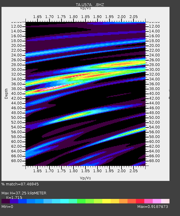
| Estimated Moho Depth: |
37.25 km |
| Estimated Crust Vp/Vs: |
1.72 |
| Assumed Crust Vp: |
6.419 km/s |
| Estimated Crust Vs: |
3.743 km/s |
| Estimated Crust Poisson's Ratio: |
0.24 |
|
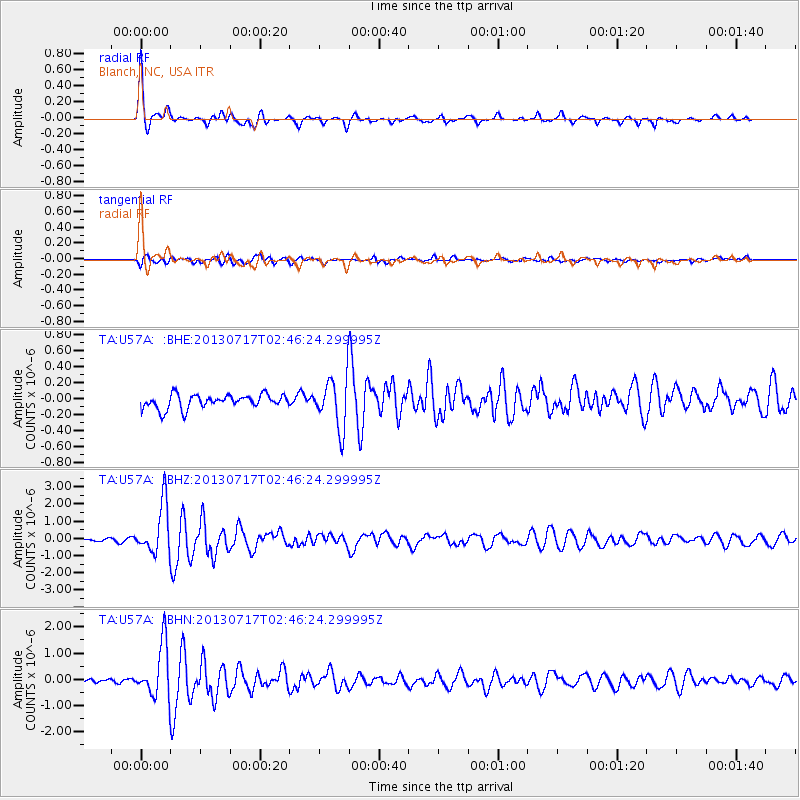
| Radial Match: |
87.46945 % |
| Radial Bump: |
339 |
| Transverse Match: |
77.932915 % |
| Transverse Bump: |
400 |
| SOD ConfigId: |
512894 |
| Insert Time: |
2013-09-15 20:43:54.151 +0000 |
| GWidth: |
2.5 |
| Max Bumps: |
400 |
| Tol: |
0.001 |
|
Signal To Noise
| Channel | StoN | STA | LTA |
| TA:U57A: :BHZ:20130717T02:46:24.299995Z | 20.366856 | 1.4472665E-6 | 7.105989E-8 |
| TA:U57A: :BHN:20130717T02:46:24.299995Z | 11.922178 | 1.0142655E-6 | 8.5073836E-8 |
| TA:U57A: :BHE:20130717T02:46:24.299995Z | 3.543345 | 3.1082712E-7 | 8.772139E-8 |
| Arrivals |
| Ps | 4.4 SECOND |
| PpPs | 15 SECOND |
| PsPs/PpSs | 19 SECOND |


