You are here: Home > Network List > XD14 - Illuminating the architecture of the greater Mount St. Helens magmatic systems f Stations List
> Station MK12 "Mount St Helens, WA" > Earthquake Result Viewer
MK12 "Mount St Helens, WA" - Earthquake Result Viewer
| Earthquake location: |
Central Peru |
| Earthquake latitude/longitude: |
-14.6/-73.6 |
| Earthquake time(UTC): |
2014/08/24 (236) 23:21:45 GMT |
| Earthquake Depth: |
101 km |
| Earthquake Magnitude: |
6.9 MWW, 6.8 MI, 6.9 MWB |
| Earthquake Catalog/Contributor: |
NEIC PDE/NEIC COMCAT |
|
| Network: |
XD Illuminating the architecture of the greater Mount St. Helens magmatic systems f |
| Station: |
MK12 "Mount St Helens, WA" |
| Lat/Lon: |
46.11 N/121.36 W |
| Elevation: |
1226 m |
|
| Distance: |
74.2 deg |
| Az: |
327.62 deg |
| Baz: |
131.812 deg |
| Ray Param: |
0.052270398 |
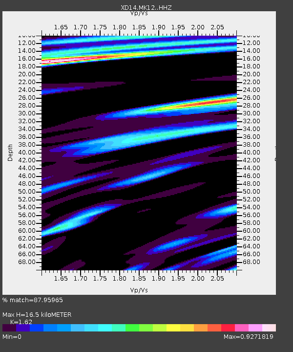
| Estimated Moho Depth: |
16.5 km |
| Estimated Crust Vp/Vs: |
1.62 |
| Assumed Crust Vp: |
6.597 km/s |
| Estimated Crust Vs: |
4.073 km/s |
| Estimated Crust Poisson's Ratio: |
0.19 |
|
| Radial Match: |
87.95965 % |
| Radial Bump: |
400 |
| Transverse Match: |
83.35833 % |
| Transverse Bump: |
400 |
| SOD ConfigId: |
3390531 |
| Insert Time: |
2019-04-13 14:37:16.531 +0000 |
| GWidth: |
2.5 |
| Max Bumps: |
400 |
| Tol: |
0.001 |
|

Signal To Noise
| Channel | StoN | STA | LTA |
| XD:MK12: :HHZ:20140824T23:32:39.649983Z | 61.900375 | 6.2699637E-6 | 1.0129121E-7 |
| XD:MK12: :HHN:20140824T23:32:39.649983Z | 12.329703 | 1.8190389E-6 | 1.4753306E-7 |
| XD:MK12: :HHE:20140824T23:32:39.649983Z | 23.07653 | 1.8973955E-6 | 8.222187E-8 |
| Arrivals |
| Ps | 1.6 SECOND |
| PpPs | 6.3 SECOND |
| PsPs/PpSs | 7.9 SECOND |


