You are here: Home > Network List > TA - USArray Transportable Network (new EarthScope stations) Stations List
> Station V46A Holladay, TN, USA > Earthquake Result Viewer
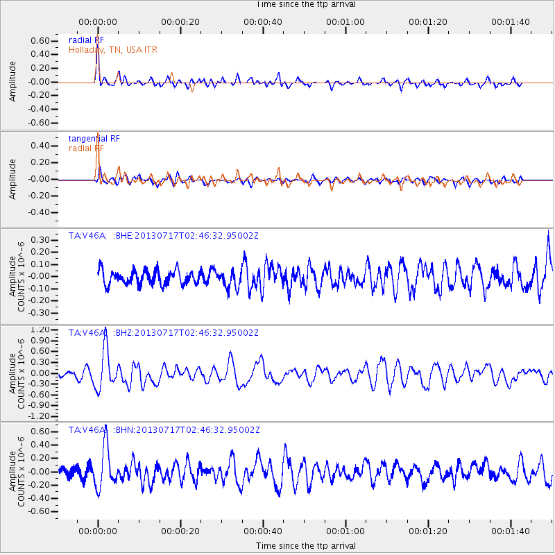
V46A Holladay, TN, USA - Earthquake Result Viewer
*The percent match for this event was below the threshold and hence no stack was calculated.
| Earthquake location: |
Southern Peru |
| Earthquake latitude/longitude: |
-15.7/-71.7 |
| Earthquake time(UTC): |
2013/07/17 (198) 02:37:43 GMT |
| Earthquake Depth: |
7.0 km |
| Earthquake Magnitude: |
6.0 MW, 5.6 MB, 5.8 MS, 5.8 MW |
| Earthquake Catalog/Contributor: |
NEIC PDE/NEIC PDE-W |
|
| Network: |
TA USArray Transportable Network (new EarthScope stations) |
| Station: |
V46A Holladay, TN, USA |
| Lat/Lon: |
35.80 N/88.12 W |
| Elevation: |
162 m |
|
| Distance: |
53.5 deg |
| Az: |
343.427 deg |
| Baz: |
160.244 deg |
| Ray Param: |
$rayparam |
*The percent match for this event was below the threshold and hence was not used in the summary stack. |
|
| Radial Match: |
72.791756 % |
| Radial Bump: |
400 |
| Transverse Match: |
46.72707 % |
| Transverse Bump: |
400 |
| SOD ConfigId: |
512894 |
| Insert Time: |
2013-09-15 20:44:15.619 +0000 |
| GWidth: |
2.5 |
| Max Bumps: |
400 |
| Tol: |
0.001 |
|
Signal To Noise
| Channel | StoN | STA | LTA |
| TA:V46A: :BHZ:20130717T02:46:32.95002Z | 3.9495199 | 5.659192E-7 | 1.432881E-7 |
| TA:V46A: :BHN:20130717T02:46:32.95002Z | 2.8117988 | 3.1871727E-7 | 1.1334995E-7 |
| TA:V46A: :BHE:20130717T02:46:32.95002Z | 1.2095653 | 6.9756965E-8 | 5.7671105E-8 |
| Arrivals |
| Ps | |
| PpPs | |
| PsPs/PpSs | |


