You are here: Home > Network List > TA - USArray Transportable Network (new EarthScope stations) Stations List
> Station V55A Taylorsville, NC, USA > Earthquake Result Viewer
V55A Taylorsville, NC, USA - Earthquake Result Viewer
| Earthquake location: |
Southern Peru |
| Earthquake latitude/longitude: |
-15.7/-71.7 |
| Earthquake time(UTC): |
2013/07/17 (198) 02:37:43 GMT |
| Earthquake Depth: |
7.0 km |
| Earthquake Magnitude: |
6.0 MW, 5.6 MB, 5.8 MS, 5.8 MW |
| Earthquake Catalog/Contributor: |
NEIC PDE/NEIC PDE-W |
|
| Network: |
TA USArray Transportable Network (new EarthScope stations) |
| Station: |
V55A Taylorsville, NC, USA |
| Lat/Lon: |
35.85 N/81.21 W |
| Elevation: |
306 m |
|
| Distance: |
52.0 deg |
| Az: |
350.23 deg |
| Baz: |
168.391 deg |
| Ray Param: |
0.06704586 |
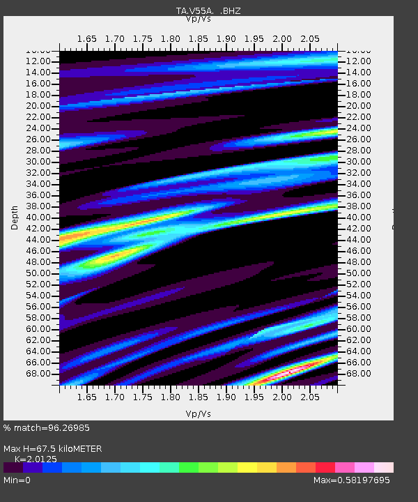
| Estimated Moho Depth: |
67.5 km |
| Estimated Crust Vp/Vs: |
2.01 |
| Assumed Crust Vp: |
6.419 km/s |
| Estimated Crust Vs: |
3.19 km/s |
| Estimated Crust Poisson's Ratio: |
0.34 |
|
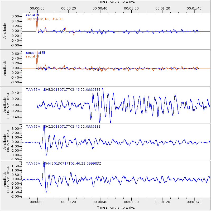
| Radial Match: |
96.26985 % |
| Radial Bump: |
330 |
| Transverse Match: |
86.683334 % |
| Transverse Bump: |
400 |
| SOD ConfigId: |
512894 |
| Insert Time: |
2013-09-15 20:44:47.366 +0000 |
| GWidth: |
2.5 |
| Max Bumps: |
400 |
| Tol: |
0.001 |
|
Signal To Noise
| Channel | StoN | STA | LTA |
| TA:V55A: :BHZ:20130717T02:46:22.099983Z | 11.011619 | 1.6237966E-6 | 1.4746212E-7 |
| TA:V55A: :BHN:20130717T02:46:22.099983Z | 9.600579 | 8.397499E-7 | 8.746867E-8 |
| TA:V55A: :BHE:20130717T02:46:22.099983Z | 2.5450916 | 1.8677623E-7 | 7.338684E-8 |
| Arrivals |
| Ps | 11 SECOND |
| PpPs | 30 SECOND |
| PsPs/PpSs | 41 SECOND |


