You are here: Home > Network List > TA - USArray Transportable Network (new EarthScope stations) Stations List
> Station W46A Michie, TN, USA > Earthquake Result Viewer
W46A Michie, TN, USA - Earthquake Result Viewer
| Earthquake location: |
Southern Peru |
| Earthquake latitude/longitude: |
-15.7/-71.7 |
| Earthquake time(UTC): |
2013/07/17 (198) 02:37:43 GMT |
| Earthquake Depth: |
7.0 km |
| Earthquake Magnitude: |
6.0 MW, 5.6 MB, 5.8 MS, 5.8 MW |
| Earthquake Catalog/Contributor: |
NEIC PDE/NEIC PDE-W |
|
| Network: |
TA USArray Transportable Network (new EarthScope stations) |
| Station: |
W46A Michie, TN, USA |
| Lat/Lon: |
35.13 N/88.38 W |
| Elevation: |
145 m |
|
| Distance: |
52.9 deg |
| Az: |
342.893 deg |
| Baz: |
159.773 deg |
| Ray Param: |
0.066452965 |
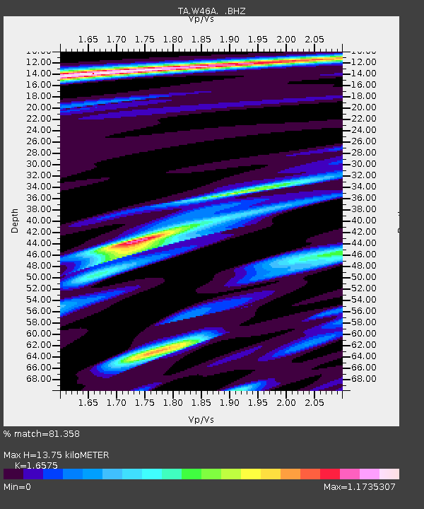
| Estimated Moho Depth: |
13.75 km |
| Estimated Crust Vp/Vs: |
1.66 |
| Assumed Crust Vp: |
6.38 km/s |
| Estimated Crust Vs: |
3.849 km/s |
| Estimated Crust Poisson's Ratio: |
0.21 |
|
| Radial Match: |
81.358 % |
| Radial Bump: |
400 |
| Transverse Match: |
62.305286 % |
| Transverse Bump: |
400 |
| SOD ConfigId: |
512894 |
| Insert Time: |
2013-09-15 20:45:22.962 +0000 |
| GWidth: |
2.5 |
| Max Bumps: |
400 |
| Tol: |
0.001 |
|

Signal To Noise
| Channel | StoN | STA | LTA |
| TA:W46A: :BHZ:20130717T02:46:28.875007Z | 6.62544 | 6.701914E-7 | 1.0115424E-7 |
| TA:W46A: :BHN:20130717T02:46:28.875007Z | 3.408111 | 3.057298E-7 | 8.9706525E-8 |
| TA:W46A: :BHE:20130717T02:46:28.875007Z | 1.2036461 | 1.2966169E-7 | 1.0772409E-7 |
| Arrivals |
| Ps | 1.5 SECOND |
| PpPs | 5.4 SECOND |
| PsPs/PpSs | 6.9 SECOND |


