You are here: Home > Network List > TA - USArray Transportable Network (new EarthScope stations) Stations List
> Station W49A Belvidere, TN, USA > Earthquake Result Viewer
W49A Belvidere, TN, USA - Earthquake Result Viewer

| Earthquake location: |
Southern Peru |
| Earthquake latitude/longitude: |
-15.7/-71.7 |
| Earthquake time(UTC): |
2013/07/17 (198) 02:37:43 GMT |
| Earthquake Depth: |
7.0 km |
| Earthquake Magnitude: |
6.0 MW, 5.6 MB, 5.8 MS, 5.8 MW |
| Earthquake Catalog/Contributor: |
NEIC PDE/NEIC PDE-W |
|
| Network: |
TA USArray Transportable Network (new EarthScope stations) |
| Station: |
W49A Belvidere, TN, USA |
| Lat/Lon: |
35.12 N/86.26 W |
| Elevation: |
251 m |
|
| Distance: |
52.3 deg |
| Az: |
344.949 deg |
| Baz: |
162.232 deg |
| Ray Param: |
0.06682577 |
| Estimated Moho Depth: |
49.25 km |
| Estimated Crust Vp/Vs: |
1.68 |
| Assumed Crust Vp: |
6.476 km/s |
| Estimated Crust Vs: |
3.855 km/s |
| Estimated Crust Poisson's Ratio: |
0.23 |
|
| Radial Match: |
83.56459 % |
| Radial Bump: |
274 |
| Transverse Match: |
67.0101 % |
| Transverse Bump: |
400 |
| SOD ConfigId: |
512894 |
| Insert Time: |
2013-09-15 20:45:29.442 +0000 |
| GWidth: |
2.5 |
| Max Bumps: |
400 |
| Tol: |
0.001 |
|
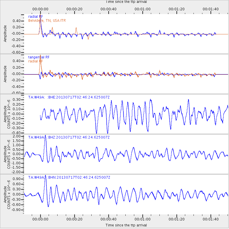
Signal To Noise
| Channel | StoN | STA | LTA |
| TA:W49A: :BHZ:20130717T02:46:24.625007Z | 6.5287857 | 9.276068E-7 | 1.4207953E-7 |
| TA:W49A: :BHN:20130717T02:46:24.625007Z | 10.619949 | 5.2732565E-7 | 4.9654254E-8 |
| TA:W49A: :BHE:20130717T02:46:24.625007Z | 1.8651109 | 1.6394452E-7 | 8.790068E-8 |
| Arrivals |
| Ps | 5.5 SECOND |
| PpPs | 19 SECOND |
| PsPs/PpSs | 25 SECOND |


