You are here: Home > Network List > XD14 - Illuminating the architecture of the greater Mount St. Helens magmatic systems f Stations List
> Station MO07 "Mount St Helens, WA" > Earthquake Result Viewer
MO07 "Mount St Helens, WA" - Earthquake Result Viewer
| Earthquake location: |
Central Peru |
| Earthquake latitude/longitude: |
-14.6/-73.6 |
| Earthquake time(UTC): |
2014/08/24 (236) 23:21:45 GMT |
| Earthquake Depth: |
101 km |
| Earthquake Magnitude: |
6.9 MWW, 6.8 MI, 6.9 MWB |
| Earthquake Catalog/Contributor: |
NEIC PDE/NEIC COMCAT |
|
| Network: |
XD Illuminating the architecture of the greater Mount St. Helens magmatic systems f |
| Station: |
MO07 "Mount St Helens, WA" |
| Lat/Lon: |
45.89 N/122.08 W |
| Elevation: |
1248 m |
|
| Distance: |
74.4 deg |
| Az: |
327.097 deg |
| Baz: |
131.154 deg |
| Ray Param: |
0.052120056 |
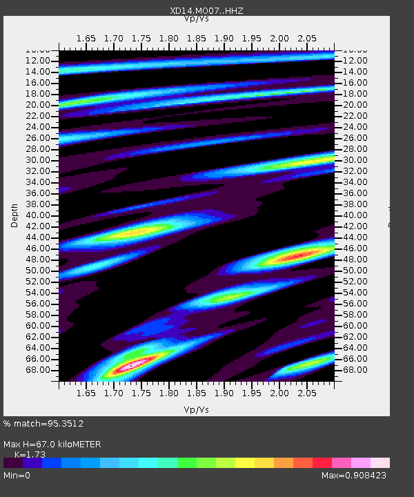
| Estimated Moho Depth: |
67.0 km |
| Estimated Crust Vp/Vs: |
1.73 |
| Assumed Crust Vp: |
6.566 km/s |
| Estimated Crust Vs: |
3.795 km/s |
| Estimated Crust Poisson's Ratio: |
0.25 |
|
| Radial Match: |
95.3512 % |
| Radial Bump: |
382 |
| Transverse Match: |
92.52075 % |
| Transverse Bump: |
400 |
| SOD ConfigId: |
3390531 |
| Insert Time: |
2019-04-13 14:37:27.667 +0000 |
| GWidth: |
2.5 |
| Max Bumps: |
400 |
| Tol: |
0.001 |
|

Signal To Noise
| Channel | StoN | STA | LTA |
| XD:MO07: :HHZ:20140824T23:32:40.964985Z | 99.99112 | 7.715423E-6 | 7.716108E-8 |
| XD:MO07: :HHN:20140824T23:32:40.964985Z | 31.326437 | 2.3296293E-6 | 7.436624E-8 |
| XD:MO07: :HHE:20140824T23:32:40.964985Z | 22.784632 | 1.949533E-6 | 8.556351E-8 |
| Arrivals |
| Ps | 7.7 SECOND |
| PpPs | 27 SECOND |
| PsPs/PpSs | 35 SECOND |


