You are here: Home > Network List > XD14 - Illuminating the architecture of the greater Mount St. Helens magmatic systems f Stations List
> Station MP04 "Mount St Helens, WA" > Earthquake Result Viewer
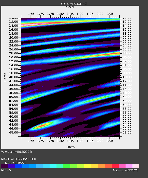
MP04 "Mount St Helens, WA" - Earthquake Result Viewer
| Earthquake location: |
Central Peru |
| Earthquake latitude/longitude: |
-14.6/-73.6 |
| Earthquake time(UTC): |
2014/08/24 (236) 23:21:45 GMT |
| Earthquake Depth: |
101 km |
| Earthquake Magnitude: |
6.9 MWW, 6.8 MI, 6.9 MWB |
| Earthquake Catalog/Contributor: |
NEIC PDE/NEIC COMCAT |
|
| Network: |
XD Illuminating the architecture of the greater Mount St. Helens magmatic systems f |
| Station: |
MP04 "Mount St Helens, WA" |
| Lat/Lon: |
45.81 N/122.38 W |
| Elevation: |
497 m |
|
| Distance: |
74.5 deg |
| Az: |
326.899 deg |
| Baz: |
130.889 deg |
| Ray Param: |
0.05204736 |
| Estimated Moho Depth: |
13.5 km |
| Estimated Crust Vp/Vs: |
1.61 |
| Assumed Crust Vp: |
6.566 km/s |
| Estimated Crust Vs: |
4.072 km/s |
| Estimated Crust Poisson's Ratio: |
0.19 |
|
| Radial Match: |
86.82118 % |
| Radial Bump: |
400 |
| Transverse Match: |
87.71412 % |
| Transverse Bump: |
400 |
| SOD ConfigId: |
3390531 |
| Insert Time: |
2019-04-13 14:37:28.781 +0000 |
| GWidth: |
2.5 |
| Max Bumps: |
400 |
| Tol: |
0.001 |
|

Signal To Noise
| Channel | StoN | STA | LTA |
| XD:MP04: :HHZ:20140824T23:32:41.59499Z | 79.63365 | 9.228294E-6 | 1.15884355E-7 |
| XD:MP04: :HHN:20140824T23:32:41.59499Z | 17.883787 | 2.3022735E-6 | 1.2873522E-7 |
| XD:MP04: :HHE:20140824T23:32:41.59499Z | 16.414774 | 1.7593179E-6 | 1.0717893E-7 |
| Arrivals |
| Ps | 1.3 SECOND |
| PpPs | 5.2 SECOND |
| PsPs/PpSs | 6.5 SECOND |


