You are here: Home > Network List > TA - USArray Transportable Network (new EarthScope stations) Stations List
> Station X47A Russelville, AR, USA > Earthquake Result Viewer
X47A Russelville, AR, USA - Earthquake Result Viewer
| Earthquake location: |
Southern Peru |
| Earthquake latitude/longitude: |
-15.7/-71.7 |
| Earthquake time(UTC): |
2013/07/17 (198) 02:37:43 GMT |
| Earthquake Depth: |
7.0 km |
| Earthquake Magnitude: |
6.0 MW, 5.6 MB, 5.8 MS, 5.8 MW |
| Earthquake Catalog/Contributor: |
NEIC PDE/NEIC PDE-W |
|
| Network: |
TA USArray Transportable Network (new EarthScope stations) |
| Station: |
X47A Russelville, AR, USA |
| Lat/Lon: |
34.52 N/87.86 W |
| Elevation: |
212 m |
|
| Distance: |
52.2 deg |
| Az: |
343.136 deg |
| Baz: |
160.217 deg |
| Ray Param: |
0.06691948 |
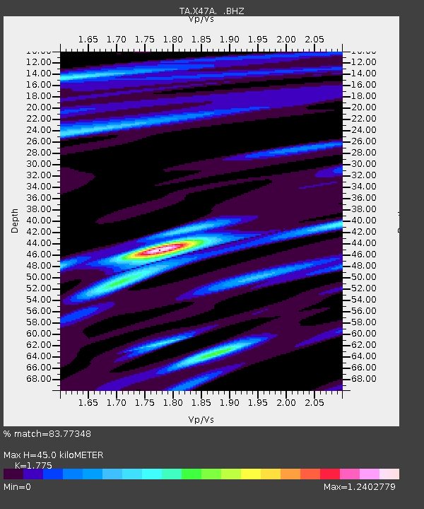
| Estimated Moho Depth: |
45.0 km |
| Estimated Crust Vp/Vs: |
1.77 |
| Assumed Crust Vp: |
6.476 km/s |
| Estimated Crust Vs: |
3.648 km/s |
| Estimated Crust Poisson's Ratio: |
0.27 |
|
| Radial Match: |
83.77348 % |
| Radial Bump: |
400 |
| Transverse Match: |
65.9436 % |
| Transverse Bump: |
400 |
| SOD ConfigId: |
512894 |
| Insert Time: |
2013-09-15 20:46:20.701 +0000 |
| GWidth: |
2.5 |
| Max Bumps: |
400 |
| Tol: |
0.001 |
|

Signal To Noise
| Channel | StoN | STA | LTA |
| TA:X47A: :BHZ:20130717T02:46:23.524971Z | 8.099618 | 9.881081E-7 | 1.219944E-7 |
| TA:X47A: :BHN:20130717T02:46:23.524971Z | 4.0225687 | 3.597089E-7 | 8.9422684E-8 |
| TA:X47A: :BHE:20130717T02:46:23.524971Z | 1.8140973 | 1.4703944E-7 | 8.105378E-8 |
| Arrivals |
| Ps | 5.7 SECOND |
| PpPs | 18 SECOND |
| PsPs/PpSs | 24 SECOND |


