You are here: Home > Network List > TA - USArray Transportable Network (new EarthScope stations) Stations List
> Station X55A Gracelyn & Ava, Whitmire, SC, USA > Earthquake Result Viewer
X55A Gracelyn & Ava, Whitmire, SC, USA - Earthquake Result Viewer
| Earthquake location: |
Southern Peru |
| Earthquake latitude/longitude: |
-15.7/-71.7 |
| Earthquake time(UTC): |
2013/07/17 (198) 02:37:43 GMT |
| Earthquake Depth: |
7.0 km |
| Earthquake Magnitude: |
6.0 MW, 5.6 MB, 5.8 MS, 5.8 MW |
| Earthquake Catalog/Contributor: |
NEIC PDE/NEIC PDE-W |
|
| Network: |
TA USArray Transportable Network (new EarthScope stations) |
| Station: |
X55A Gracelyn & Ava, Whitmire, SC, USA |
| Lat/Lon: |
34.47 N/81.63 W |
| Elevation: |
153 m |
|
| Distance: |
50.7 deg |
| Az: |
349.434 deg |
| Baz: |
167.654 deg |
| Ray Param: |
0.067867935 |
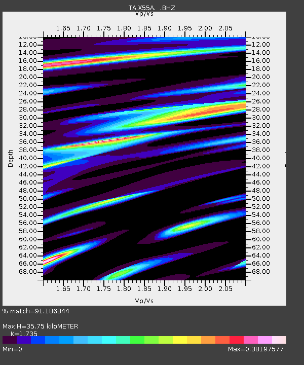
| Estimated Moho Depth: |
35.75 km |
| Estimated Crust Vp/Vs: |
1.74 |
| Assumed Crust Vp: |
6.419 km/s |
| Estimated Crust Vs: |
3.7 km/s |
| Estimated Crust Poisson's Ratio: |
0.25 |
|
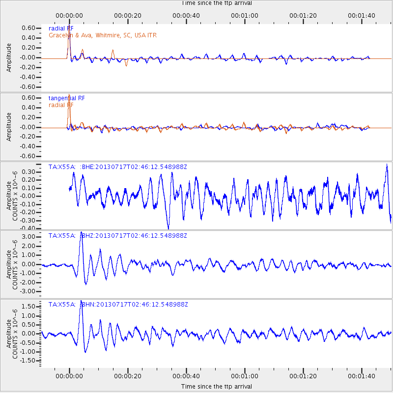
| Radial Match: |
91.186844 % |
| Radial Bump: |
309 |
| Transverse Match: |
61.82689 % |
| Transverse Bump: |
400 |
| SOD ConfigId: |
512894 |
| Insert Time: |
2013-09-15 20:46:51.865 +0000 |
| GWidth: |
2.5 |
| Max Bumps: |
400 |
| Tol: |
0.001 |
|
Signal To Noise
| Channel | StoN | STA | LTA |
| TA:X55A: :BHZ:20130717T02:46:12.548988Z | 16.96835 | 1.4632682E-6 | 8.6235154E-8 |
| TA:X55A: :BHN:20130717T02:46:12.548988Z | 8.352141 | 7.4931336E-7 | 8.971512E-8 |
| TA:X55A: :BHE:20130717T02:46:12.548988Z | 2.2131345 | 2.0442971E-7 | 9.237112E-8 |
| Arrivals |
| Ps | 4.3 SECOND |
| PpPs | 14 SECOND |
| PsPs/PpSs | 19 SECOND |


