You are here: Home > Network List > TA - USArray Transportable Network (new EarthScope stations) Stations List
> Station X59A McDuffie Farm, Elizabethtown, NC, USA > Earthquake Result Viewer
X59A McDuffie Farm, Elizabethtown, NC, USA - Earthquake Result Viewer
| Earthquake location: |
Southern Peru |
| Earthquake latitude/longitude: |
-15.7/-71.7 |
| Earthquake time(UTC): |
2013/07/17 (198) 02:37:43 GMT |
| Earthquake Depth: |
7.0 km |
| Earthquake Magnitude: |
6.0 MW, 5.6 MB, 5.8 MS, 5.8 MW |
| Earthquake Catalog/Contributor: |
NEIC PDE/NEIC PDE-W |
|
| Network: |
TA USArray Transportable Network (new EarthScope stations) |
| Station: |
X59A McDuffie Farm, Elizabethtown, NC, USA |
| Lat/Lon: |
34.57 N/78.60 W |
| Elevation: |
29 m |
|
| Distance: |
50.4 deg |
| Az: |
352.645 deg |
| Baz: |
171.405 deg |
| Ray Param: |
0.068107925 |
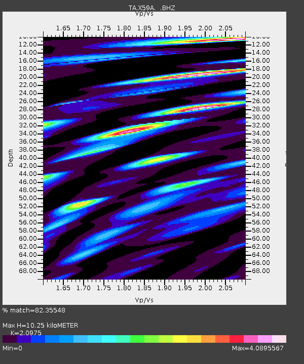
| Estimated Moho Depth: |
10.25 km |
| Estimated Crust Vp/Vs: |
2.10 |
| Assumed Crust Vp: |
6.565 km/s |
| Estimated Crust Vs: |
3.13 km/s |
| Estimated Crust Poisson's Ratio: |
0.35 |
|
| Radial Match: |
82.35548 % |
| Radial Bump: |
400 |
| Transverse Match: |
52.78619 % |
| Transverse Bump: |
400 |
| SOD ConfigId: |
512894 |
| Insert Time: |
2013-09-15 20:47:06.203 +0000 |
| GWidth: |
2.5 |
| Max Bumps: |
400 |
| Tol: |
0.001 |
|
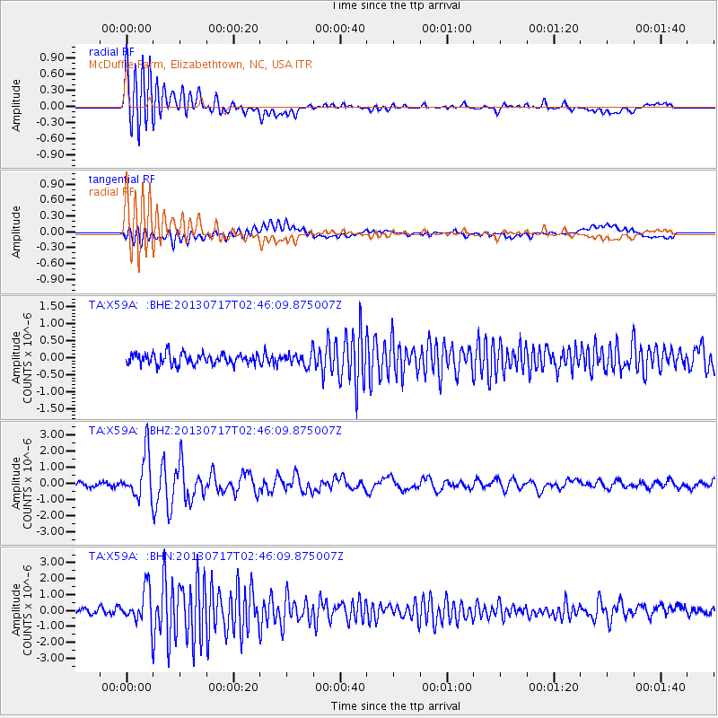
Signal To Noise
| Channel | StoN | STA | LTA |
| TA:X59A: :BHZ:20130717T02:46:09.875007Z | 10.06153 | 1.3923212E-6 | 1.3838067E-7 |
| TA:X59A: :BHN:20130717T02:46:09.875007Z | 5.003821 | 1.1378776E-6 | 2.2740171E-7 |
| TA:X59A: :BHE:20130717T02:46:09.875007Z | 1.1527646 | 1.8210501E-7 | 1.5797241E-7 |
| Arrivals |
| Ps | 1.8 SECOND |
| PpPs | 4.6 SECOND |
| PsPs/PpSs | 6.4 SECOND |


