You are here: Home > Network List > TA - USArray Transportable Network (new EarthScope stations) Stations List
> Station Y52A Lilburn, GA, USA > Earthquake Result Viewer
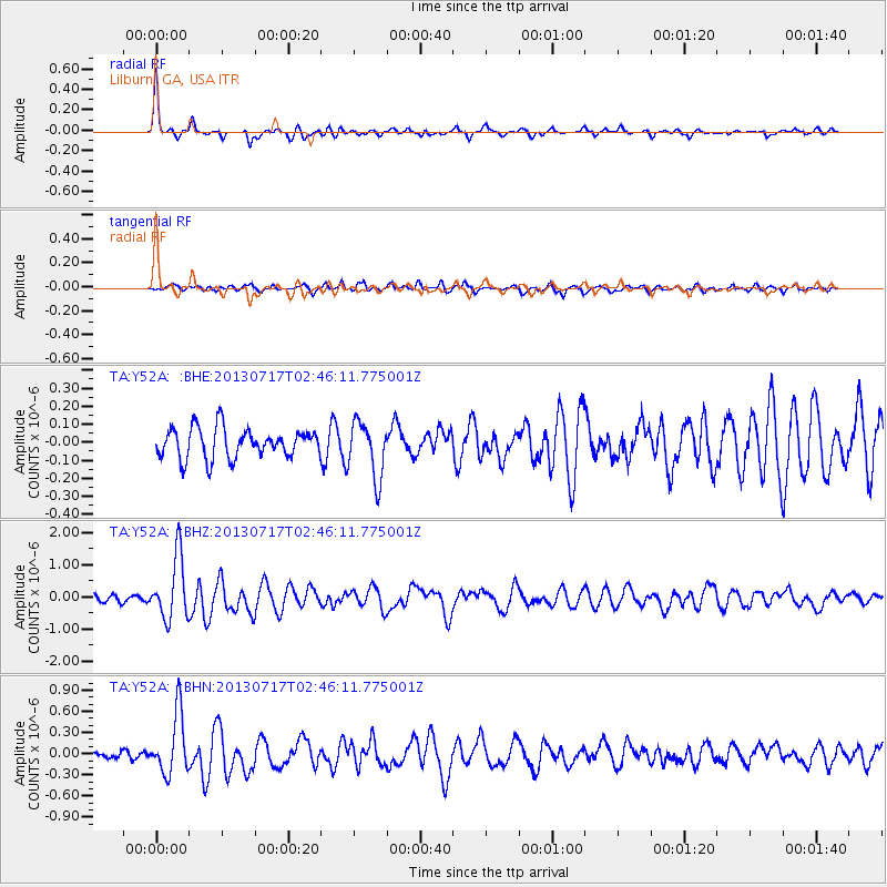
Y52A Lilburn, GA, USA - Earthquake Result Viewer

| Earthquake location: |
Southern Peru |
| Earthquake latitude/longitude: |
-15.7/-71.7 |
| Earthquake time(UTC): |
2013/07/17 (198) 02:37:43 GMT |
| Earthquake Depth: |
7.0 km |
| Earthquake Magnitude: |
6.0 MW, 5.6 MB, 5.8 MS, 5.8 MW |
| Earthquake Catalog/Contributor: |
NEIC PDE/NEIC PDE-W |
|
| Network: |
TA USArray Transportable Network (new EarthScope stations) |
| Station: |
Y52A Lilburn, GA, USA |
| Lat/Lon: |
33.86 N/84.06 W |
| Elevation: |
286 m |
|
| Distance: |
50.6 deg |
| Az: |
346.719 deg |
| Baz: |
164.576 deg |
| Ray Param: |
0.067938186 |
| Estimated Moho Depth: |
43.75 km |
| Estimated Crust Vp/Vs: |
1.79 |
| Assumed Crust Vp: |
6.719 km/s |
| Estimated Crust Vs: |
3.759 km/s |
| Estimated Crust Poisson's Ratio: |
0.27 |
|
| Radial Match: |
87.1141 % |
| Radial Bump: |
387 |
| Transverse Match: |
67.06416 % |
| Transverse Bump: |
400 |
| SOD ConfigId: |
512894 |
| Insert Time: |
2013-09-15 20:47:32.153 +0000 |
| GWidth: |
2.5 |
| Max Bumps: |
400 |
| Tol: |
0.001 |
|
Signal To Noise
| Channel | StoN | STA | LTA |
| TA:Y52A: :BHZ:20130717T02:46:11.775001Z | 10.02396 | 9.73674E-7 | 9.7134674E-8 |
| TA:Y52A: :BHN:20130717T02:46:11.775001Z | 9.110935 | 4.2825138E-7 | 4.7004107E-8 |
| TA:Y52A: :BHE:20130717T02:46:11.775001Z | 1.9157071 | 1.5684118E-7 | 8.187117E-8 |
| Arrivals |
| Ps | 5.5 SECOND |
| PpPs | 17 SECOND |
| PsPs/PpSs | 23 SECOND |


