You are here: Home > Network List > TA - USArray Transportable Network (new EarthScope stations) Stations List
> Station Z55A Blythe, GA, USA > Earthquake Result Viewer
Z55A Blythe, GA, USA - Earthquake Result Viewer
| Earthquake location: |
Southern Peru |
| Earthquake latitude/longitude: |
-15.7/-71.7 |
| Earthquake time(UTC): |
2013/07/17 (198) 02:37:43 GMT |
| Earthquake Depth: |
7.0 km |
| Earthquake Magnitude: |
6.0 MW, 5.6 MB, 5.8 MS, 5.8 MW |
| Earthquake Catalog/Contributor: |
NEIC PDE/NEIC PDE-W |
|
| Network: |
TA USArray Transportable Network (new EarthScope stations) |
| Station: |
Z55A Blythe, GA, USA |
| Lat/Lon: |
33.22 N/82.14 W |
| Elevation: |
100 m |
|
| Distance: |
49.6 deg |
| Az: |
348.545 deg |
| Baz: |
166.806 deg |
| Ray Param: |
0.068600394 |
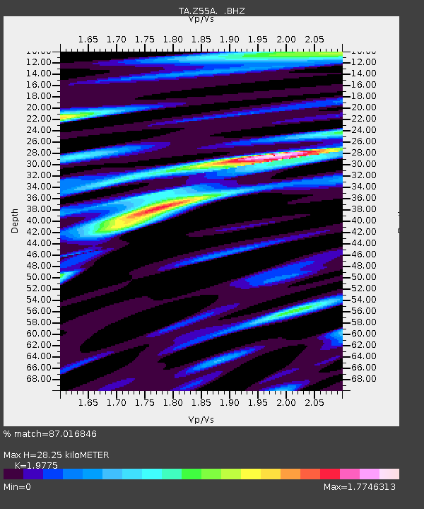
| Estimated Moho Depth: |
28.25 km |
| Estimated Crust Vp/Vs: |
1.98 |
| Assumed Crust Vp: |
6.565 km/s |
| Estimated Crust Vs: |
3.32 km/s |
| Estimated Crust Poisson's Ratio: |
0.33 |
|
| Radial Match: |
87.016846 % |
| Radial Bump: |
400 |
| Transverse Match: |
62.728477 % |
| Transverse Bump: |
400 |
| SOD ConfigId: |
512894 |
| Insert Time: |
2013-09-15 20:48:27.916 +0000 |
| GWidth: |
2.5 |
| Max Bumps: |
400 |
| Tol: |
0.001 |
|
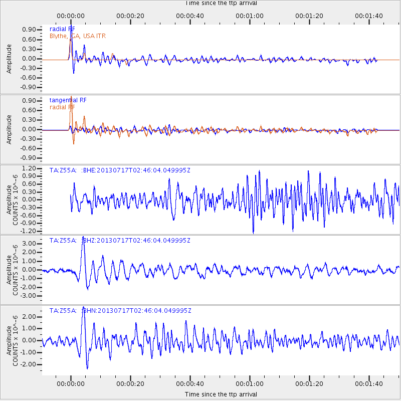
Signal To Noise
| Channel | StoN | STA | LTA |
| TA:Z55A: :BHZ:20130717T02:46:04.049995Z | 10.901092 | 1.504093E-6 | 1.3797636E-7 |
| TA:Z55A: :BHN:20130717T02:46:04.049995Z | 6.790569 | 1.1849038E-6 | 1.7449257E-7 |
| TA:Z55A: :BHE:20130717T02:46:04.049995Z | 1.8197827 | 3.8499235E-7 | 2.1155952E-7 |
| Arrivals |
| Ps | 4.4 SECOND |
| PpPs | 12 SECOND |
| PsPs/PpSs | 17 SECOND |


