You are here: Home > Network List > UU - University of Utah Regional Network Stations List
> Station JLU Jordanelle, UT, USA > Earthquake Result Viewer
JLU Jordanelle, UT, USA - Earthquake Result Viewer
| Earthquake location: |
Southern Peru |
| Earthquake latitude/longitude: |
-15.7/-71.7 |
| Earthquake time(UTC): |
2013/07/17 (198) 02:37:43 GMT |
| Earthquake Depth: |
7.0 km |
| Earthquake Magnitude: |
6.0 MW, 5.6 MB, 5.8 MS, 5.8 MW |
| Earthquake Catalog/Contributor: |
NEIC PDE/NEIC PDE-W |
|
| Network: |
UU University of Utah Regional Network |
| Station: |
JLU Jordanelle, UT, USA |
| Lat/Lon: |
40.60 N/111.45 W |
| Elevation: |
2285 m |
|
| Distance: |
67.0 deg |
| Az: |
328.103 deg |
| Baz: |
138.045 deg |
| Ray Param: |
0.05723554 |
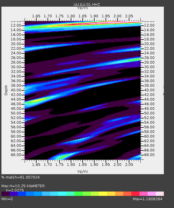
| Estimated Moho Depth: |
10.25 km |
| Estimated Crust Vp/Vs: |
2.03 |
| Assumed Crust Vp: |
6.155 km/s |
| Estimated Crust Vs: |
3.036 km/s |
| Estimated Crust Poisson's Ratio: |
0.34 |
|
| Radial Match: |
91.857834 % |
| Radial Bump: |
372 |
| Transverse Match: |
83.854324 % |
| Transverse Bump: |
400 |
| SOD ConfigId: |
512894 |
| Insert Time: |
2013-09-15 20:52:11.275 +0000 |
| GWidth: |
2.5 |
| Max Bumps: |
400 |
| Tol: |
0.001 |
|

Signal To Noise
| Channel | StoN | STA | LTA |
| UU:JLU:01:HHZ:20130717T02:48:05.518989Z | 8.048053 | 2.288275E-8 | 2.8432654E-9 |
| UU:JLU:01:HHN:20130717T02:48:05.518989Z | 3.0695264 | 5.8269567E-9 | 1.8983244E-9 |
| UU:JLU:01:HHE:20130717T02:48:05.518989Z | 3.0088985 | 5.0686833E-9 | 1.6845644E-9 |
| Arrivals |
| Ps | 1.8 SECOND |
| PpPs | 4.9 SECOND |
| PsPs/PpSs | 6.7 SECOND |


