You are here: Home > Network List > UU - University of Utah Regional Network Stations List
> Station TMU Trail Mountain (BB), UT, USA > Earthquake Result Viewer
TMU Trail Mountain (BB), UT, USA - Earthquake Result Viewer
| Earthquake location: |
Southern Peru |
| Earthquake latitude/longitude: |
-15.7/-71.7 |
| Earthquake time(UTC): |
2013/07/17 (198) 02:37:43 GMT |
| Earthquake Depth: |
7.0 km |
| Earthquake Magnitude: |
6.0 MW, 5.6 MB, 5.8 MS, 5.8 MW |
| Earthquake Catalog/Contributor: |
NEIC PDE/NEIC PDE-W |
|
| Network: |
UU University of Utah Regional Network |
| Station: |
TMU Trail Mountain (BB), UT, USA |
| Lat/Lon: |
39.30 N/111.21 W |
| Elevation: |
2731 m |
|
| Distance: |
65.9 deg |
| Az: |
327.301 deg |
| Baz: |
137.879 deg |
| Ray Param: |
0.057956997 |
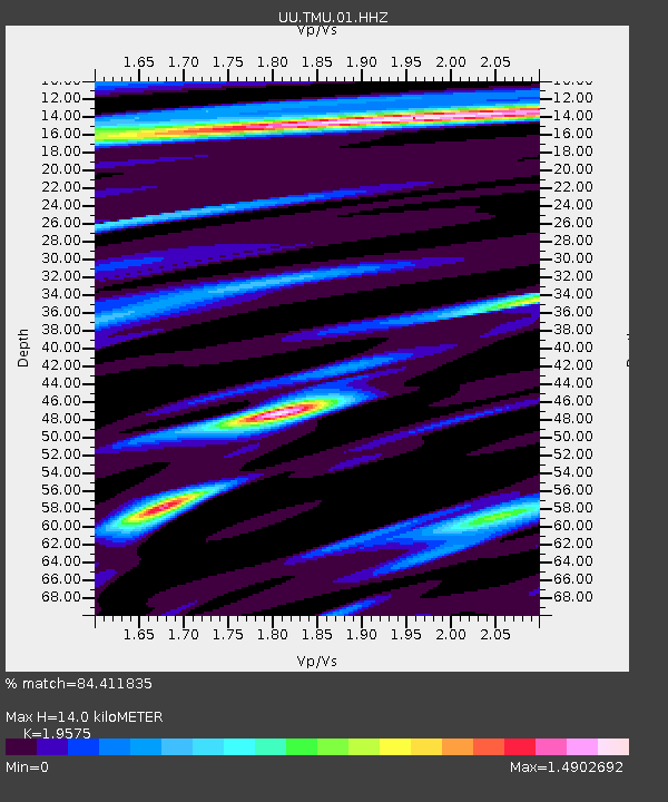
| Estimated Moho Depth: |
14.0 km |
| Estimated Crust Vp/Vs: |
1.96 |
| Assumed Crust Vp: |
6.207 km/s |
| Estimated Crust Vs: |
3.171 km/s |
| Estimated Crust Poisson's Ratio: |
0.32 |
|
| Radial Match: |
84.411835 % |
| Radial Bump: |
297 |
| Transverse Match: |
66.420746 % |
| Transverse Bump: |
358 |
| SOD ConfigId: |
512894 |
| Insert Time: |
2013-09-15 20:53:03.133 +0000 |
| GWidth: |
2.5 |
| Max Bumps: |
400 |
| Tol: |
0.001 |
|

Signal To Noise
| Channel | StoN | STA | LTA |
| UU:TMU:01:HHZ:20130717T02:47:58.549019Z | 5.4727173 | 1.7785238E-8 | 3.2498004E-9 |
| UU:TMU:01:HHN:20130717T02:47:58.549019Z | 2.5985627 | 4.9863096E-9 | 1.9188722E-9 |
| UU:TMU:01:HHE:20130717T02:47:58.549019Z | 3.763784 | 5.7100373E-9 | 1.5171001E-9 |
| Arrivals |
| Ps | 2.2 SECOND |
| PpPs | 6.4 SECOND |
| PsPs/PpSs | 8.7 SECOND |


