You are here: Home > Network List > UU - University of Utah Regional Network Stations List
> Station ZNPU Zion National Park, UT, USA > Earthquake Result Viewer
ZNPU Zion National Park, UT, USA - Earthquake Result Viewer
| Earthquake location: |
Southern Peru |
| Earthquake latitude/longitude: |
-15.7/-71.7 |
| Earthquake time(UTC): |
2013/07/17 (198) 02:37:43 GMT |
| Earthquake Depth: |
7.0 km |
| Earthquake Magnitude: |
6.0 MW, 5.6 MB, 5.8 MS, 5.8 MW |
| Earthquake Catalog/Contributor: |
NEIC PDE/NEIC PDE-W |
|
| Network: |
UU University of Utah Regional Network |
| Station: |
ZNPU Zion National Park, UT, USA |
| Lat/Lon: |
37.36 N/113.13 W |
| Elevation: |
1953 m |
|
| Distance: |
65.5 deg |
| Az: |
324.64 deg |
| Baz: |
135.602 deg |
| Ray Param: |
0.05820489 |
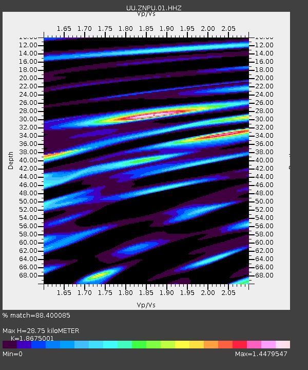
| Estimated Moho Depth: |
28.75 km |
| Estimated Crust Vp/Vs: |
1.87 |
| Assumed Crust Vp: |
6.194 km/s |
| Estimated Crust Vs: |
3.317 km/s |
| Estimated Crust Poisson's Ratio: |
0.30 |
|
| Radial Match: |
88.400085 % |
| Radial Bump: |
400 |
| Transverse Match: |
77.05241 % |
| Transverse Bump: |
400 |
| SOD ConfigId: |
512894 |
| Insert Time: |
2013-09-15 20:53:09.360 +0000 |
| GWidth: |
2.5 |
| Max Bumps: |
400 |
| Tol: |
0.001 |
|

Signal To Noise
| Channel | StoN | STA | LTA |
| UU:ZNPU:01:HHZ:20130717T02:47:56.117988Z | 5.814143 | 1.4119669E-8 | 2.4285038E-9 |
| UU:ZNPU:01:HHN:20130717T02:47:56.117988Z | 2.8485181 | 5.9406657E-9 | 2.0855284E-9 |
| UU:ZNPU:01:HHE:20130717T02:47:56.117988Z | 1.9742554 | 3.967714E-9 | 2.0097268E-9 |
| Arrivals |
| Ps | 4.2 SECOND |
| PpPs | 13 SECOND |
| PsPs/PpSs | 17 SECOND |


