You are here: Home > Network List > ZJ12 - Transantarctic Mountains Northern Network Stations List
> Station RAPH Exposure Hill, Antarctica > Earthquake Result Viewer
RAPH Exposure Hill, Antarctica - Earthquake Result Viewer
| Earthquake location: |
Central Peru |
| Earthquake latitude/longitude: |
-14.6/-73.6 |
| Earthquake time(UTC): |
2014/08/24 (236) 23:21:45 GMT |
| Earthquake Depth: |
101 km |
| Earthquake Magnitude: |
6.9 MWW, 6.8 MI, 6.9 MWB |
| Earthquake Catalog/Contributor: |
NEIC PDE/NEIC COMCAT |
|
| Network: |
ZJ Transantarctic Mountains Northern Network |
| Station: |
RAPH Exposure Hill, Antarctica |
| Lat/Lon: |
73.60 S/162.29 E |
| Elevation: |
3052 m |
|
| Distance: |
85.1 deg |
| Az: |
193.654 deg |
| Baz: |
126.453 deg |
| Ray Param: |
0.04479804 |
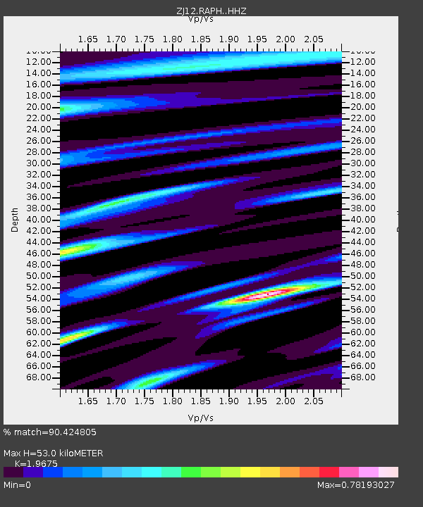
| Estimated Moho Depth: |
53.0 km |
| Estimated Crust Vp/Vs: |
1.97 |
| Assumed Crust Vp: |
6.264 km/s |
| Estimated Crust Vs: |
3.184 km/s |
| Estimated Crust Poisson's Ratio: |
0.33 |
|
| Radial Match: |
90.424805 % |
| Radial Bump: |
400 |
| Transverse Match: |
38.675865 % |
| Transverse Bump: |
400 |
| SOD ConfigId: |
3390531 |
| Insert Time: |
2019-04-13 14:39:00.360 +0000 |
| GWidth: |
2.5 |
| Max Bumps: |
400 |
| Tol: |
0.001 |
|

Signal To Noise
| Channel | StoN | STA | LTA |
| ZJ:RAPH: :HHZ:20140824T23:33:39.118977Z | 51.661102 | 8.4407075E-6 | 1.6338613E-7 |
| ZJ:RAPH: :HHN:20140824T23:33:39.118977Z | 2.1041539 | 1.4530118E-6 | 6.905445E-7 |
| ZJ:RAPH: :HHE:20140824T23:33:39.118977Z | 3.1270869 | 2.9331327E-6 | 9.379761E-7 |
| Arrivals |
| Ps | 8.4 SECOND |
| PpPs | 25 SECOND |
| PsPs/PpSs | 33 SECOND |


