You are here: Home > Network List > WY - Yellowstone Wyoming Seismic Network Stations List
> Station YNR Norris Junction, YNP, WY, USA > Earthquake Result Viewer
YNR Norris Junction, YNP, WY, USA - Earthquake Result Viewer

| Earthquake location: |
Southern Peru |
| Earthquake latitude/longitude: |
-15.7/-71.7 |
| Earthquake time(UTC): |
2013/07/17 (198) 02:37:43 GMT |
| Earthquake Depth: |
7.0 km |
| Earthquake Magnitude: |
6.0 MW, 5.6 MB, 5.8 MS, 5.8 MW |
| Earthquake Catalog/Contributor: |
NEIC PDE/NEIC PDE-W |
|
| Network: |
WY Yellowstone Wyoming Seismic Network |
| Station: |
YNR Norris Junction, YNP, WY, USA |
| Lat/Lon: |
44.72 N/110.68 W |
| Elevation: |
2336 m |
|
| Distance: |
69.7 deg |
| Az: |
331.469 deg |
| Baz: |
139.806 deg |
| Ray Param: |
0.05544826 |
| Estimated Moho Depth: |
35.5 km |
| Estimated Crust Vp/Vs: |
1.88 |
| Assumed Crust Vp: |
6.35 km/s |
| Estimated Crust Vs: |
3.378 km/s |
| Estimated Crust Poisson's Ratio: |
0.30 |
|
| Radial Match: |
80.89297 % |
| Radial Bump: |
400 |
| Transverse Match: |
76.8998 % |
| Transverse Bump: |
400 |
| SOD ConfigId: |
512894 |
| Insert Time: |
2013-09-15 20:57:00.924 +0000 |
| GWidth: |
2.5 |
| Max Bumps: |
400 |
| Tol: |
0.001 |
|
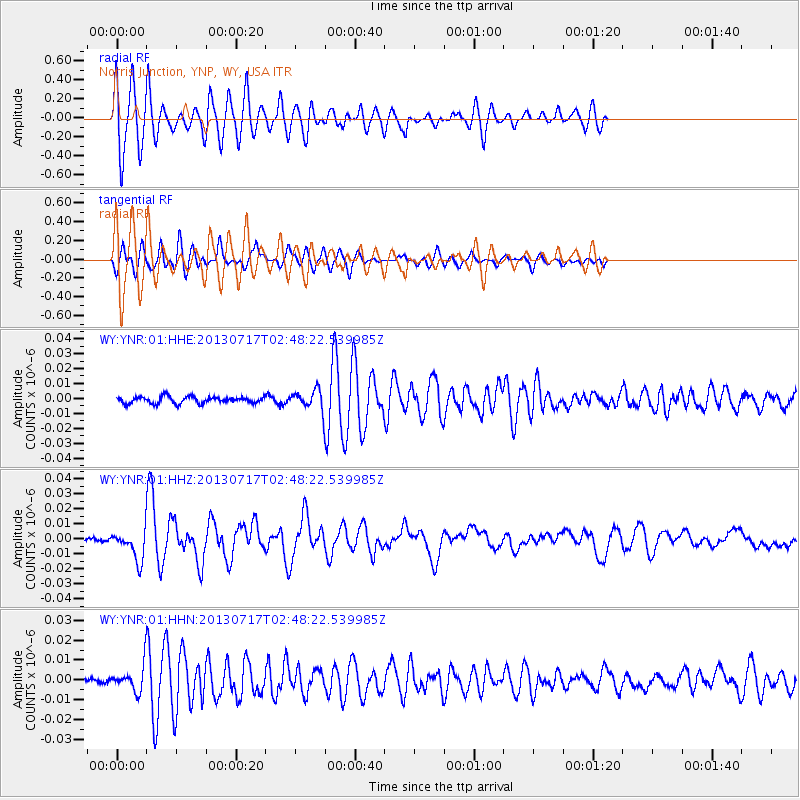
Signal To Noise
| Channel | StoN | STA | LTA |
| WY:YNR:01:HHZ:20130717T02:48:22.539985Z | 7.2761474 | 9.670897E-9 | 1.3291233E-9 |
| WY:YNR:01:HHN:20130717T02:48:22.539985Z | 2.9514446 | 5.84943E-9 | 1.981887E-9 |
| WY:YNR:01:HHE:20130717T02:48:22.539985Z | 2.7055056 | 6.0389143E-9 | 2.2320834E-9 |
| Arrivals |
| Ps | 5.1 SECOND |
| PpPs | 16 SECOND |
| PsPs/PpSs | 21 SECOND |


