You are here: Home > Network List > II - Global Seismograph Network (GSN - IRIS/IDA) Stations List
> Station WRAB Tennant Creek, NT, Australia > Earthquake Result Viewer
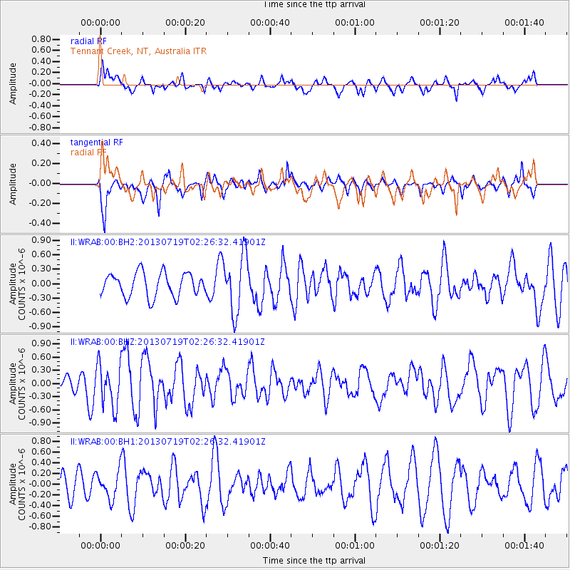
WRAB Tennant Creek, NT, Australia - Earthquake Result Viewer
*The percent match for this event was below the threshold and hence no stack was calculated.
| Earthquake location: |
Vanuatu Islands |
| Earthquake latitude/longitude: |
-16.8/167.7 |
| Earthquake time(UTC): |
2013/07/19 (200) 02:20:40 GMT |
| Earthquake Depth: |
25 km |
| Earthquake Magnitude: |
5.6 MW, 5.5 MS, 5.5 MW |
| Earthquake Catalog/Contributor: |
NEIC PDE/NEIC PDE-W |
|
| Network: |
II Global Seismograph Network (GSN - IRIS/IDA) |
| Station: |
WRAB Tennant Creek, NT, Australia |
| Lat/Lon: |
19.93 S/134.36 E |
| Elevation: |
366 m |
|
| Distance: |
31.8 deg |
| Az: |
259.11 deg |
| Baz: |
89.814 deg |
| Ray Param: |
$rayparam |
*The percent match for this event was below the threshold and hence was not used in the summary stack. |
|
| Radial Match: |
55.199978 % |
| Radial Bump: |
400 |
| Transverse Match: |
65.58081 % |
| Transverse Bump: |
400 |
| SOD ConfigId: |
512894 |
| Insert Time: |
2013-09-15 21:14:56.743 +0000 |
| GWidth: |
2.5 |
| Max Bumps: |
400 |
| Tol: |
0.001 |
|
Signal To Noise
| Channel | StoN | STA | LTA |
| II:WRAB:00:BHZ:20130719T02:26:32.41901Z | 1.8536191 | 4.9268755E-7 | 2.657976E-7 |
| II:WRAB:00:BH1:20130719T02:26:32.41901Z | 0.672915 | 2.6183884E-7 | 3.8911134E-7 |
| II:WRAB:00:BH2:20130719T02:26:32.41901Z | 2.4914265 | 6.1043716E-7 | 2.4501512E-7 |
| Arrivals |
| Ps | |
| PpPs | |
| PsPs/PpSs | |


