You are here: Home > Network List > AZ - ANZA Regional Network Stations List
> Station SMER AZ.SMER > Earthquake Result Viewer
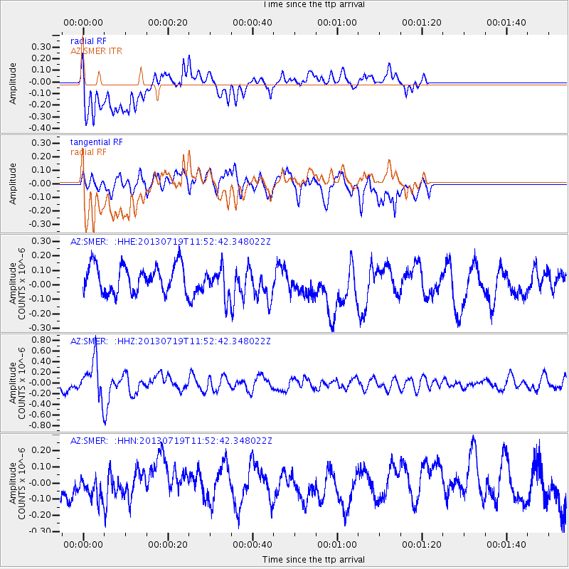
SMER AZ.SMER - Earthquake Result Viewer
*The percent match for this event was below the threshold and hence no stack was calculated.
| Earthquake location: |
Kermadec Islands Region |
| Earthquake latitude/longitude: |
-30.5/-176.3 |
| Earthquake time(UTC): |
2013/07/19 (200) 11:40:42 GMT |
| Earthquake Depth: |
22 km |
| Earthquake Magnitude: |
5.7 MW, 5.5 MB, 5.7 MW |
| Earthquake Catalog/Contributor: |
NEIC PDE/NEIC PDE-W |
|
| Network: |
AZ ANZA Regional Network |
| Station: |
SMER AZ.SMER |
| Lat/Lon: |
33.46 N/117.17 W |
| Elevation: |
355 m |
|
| Distance: |
84.6 deg |
| Az: |
46.105 deg |
| Baz: |
228.09 deg |
| Ray Param: |
$rayparam |
*The percent match for this event was below the threshold and hence was not used in the summary stack. |
|
| Radial Match: |
47.274498 % |
| Radial Bump: |
400 |
| Transverse Match: |
52.61844 % |
| Transverse Bump: |
400 |
| SOD ConfigId: |
512894 |
| Insert Time: |
2013-09-15 21:27:49.845 +0000 |
| GWidth: |
2.5 |
| Max Bumps: |
400 |
| Tol: |
0.001 |
|
Signal To Noise
| Channel | StoN | STA | LTA |
| AZ:SMER: :HHZ:20130719T11:52:42.348022Z | 2.5536344 | 3.592101E-7 | 1.4066623E-7 |
| AZ:SMER: :HHN:20130719T11:52:42.348022Z | 0.71041924 | 9.6701875E-8 | 1.3611945E-7 |
| AZ:SMER: :HHE:20130719T11:52:42.348022Z | 1.0608641 | 9.990894E-8 | 9.417694E-8 |
| Arrivals |
| Ps | |
| PpPs | |
| PsPs/PpSs | |


