You are here: Home > Network List > TA - USArray Transportable Network (new EarthScope stations) Stations List
> Station O03E Paynes Creek, CA, USA > Earthquake Result Viewer
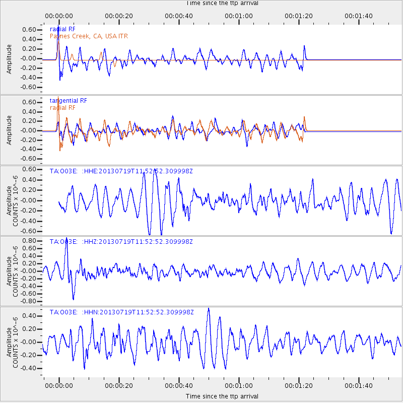
O03E Paynes Creek, CA, USA - Earthquake Result Viewer
*The percent match for this event was below the threshold and hence no stack was calculated.
| Earthquake location: |
Kermadec Islands Region |
| Earthquake latitude/longitude: |
-30.5/-176.3 |
| Earthquake time(UTC): |
2013/07/19 (200) 11:40:42 GMT |
| Earthquake Depth: |
22 km |
| Earthquake Magnitude: |
5.7 MW, 5.5 MB, 5.7 MW |
| Earthquake Catalog/Contributor: |
NEIC PDE/NEIC PDE-W |
|
| Network: |
TA USArray Transportable Network (new EarthScope stations) |
| Station: |
O03E Paynes Creek, CA, USA |
| Lat/Lon: |
40.29 N/121.80 W |
| Elevation: |
967 m |
|
| Distance: |
86.6 deg |
| Az: |
38.582 deg |
| Baz: |
224.744 deg |
| Ray Param: |
$rayparam |
*The percent match for this event was below the threshold and hence was not used in the summary stack. |
|
| Radial Match: |
48.51122 % |
| Radial Bump: |
400 |
| Transverse Match: |
49.83343 % |
| Transverse Bump: |
400 |
| SOD ConfigId: |
512894 |
| Insert Time: |
2013-09-15 21:38:43.614 +0000 |
| GWidth: |
2.5 |
| Max Bumps: |
400 |
| Tol: |
0.001 |
|
Signal To Noise
| Channel | StoN | STA | LTA |
| TA:O03E: :HHZ:20130719T11:52:52.309998Z | 4.631558 | 3.7538314E-7 | 8.1048995E-8 |
| TA:O03E: :HHN:20130719T11:52:52.309998Z | 0.68603265 | 1.1617094E-7 | 1.6933733E-7 |
| TA:O03E: :HHE:20130719T11:52:52.309998Z | 2.7339094 | 4.517309E-7 | 1.6523258E-7 |
| Arrivals |
| Ps | |
| PpPs | |
| PsPs/PpSs | |


