You are here: Home > Network List > US - United States National Seismic Network Stations List
> Station MNTX Cornudas Mountains, Texas, USA > Earthquake Result Viewer
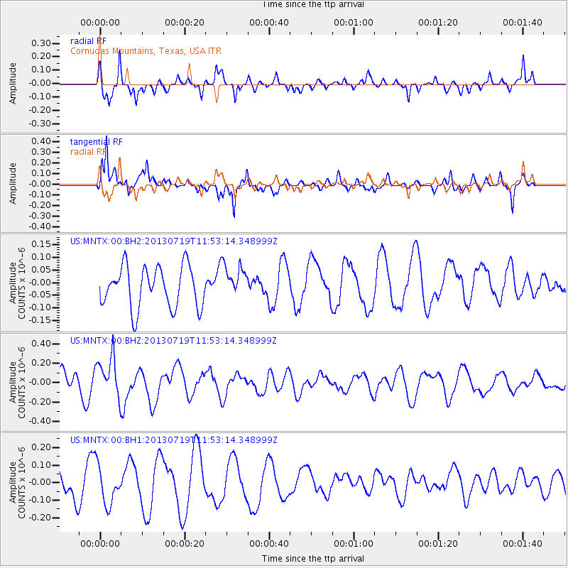
MNTX Cornudas Mountains, Texas, USA - Earthquake Result Viewer
*The percent match for this event was below the threshold and hence no stack was calculated.
| Earthquake location: |
Kermadec Islands Region |
| Earthquake latitude/longitude: |
-30.5/-176.3 |
| Earthquake time(UTC): |
2013/07/19 (200) 11:40:42 GMT |
| Earthquake Depth: |
22 km |
| Earthquake Magnitude: |
5.7 MW, 5.5 MB, 5.7 MW |
| Earthquake Catalog/Contributor: |
NEIC PDE/NEIC PDE-W |
|
| Network: |
US United States National Seismic Network |
| Station: |
MNTX Cornudas Mountains, Texas, USA |
| Lat/Lon: |
31.70 N/105.38 W |
| Elevation: |
404 m |
|
| Distance: |
91.3 deg |
| Az: |
53.678 deg |
| Baz: |
234.692 deg |
| Ray Param: |
$rayparam |
*The percent match for this event was below the threshold and hence was not used in the summary stack. |
|
| Radial Match: |
62.94495 % |
| Radial Bump: |
374 |
| Transverse Match: |
84.458755 % |
| Transverse Bump: |
400 |
| SOD ConfigId: |
512894 |
| Insert Time: |
2013-09-15 21:39:38.793 +0000 |
| GWidth: |
2.5 |
| Max Bumps: |
400 |
| Tol: |
0.001 |
|
Signal To Noise
| Channel | StoN | STA | LTA |
| US:MNTX:00:BHZ:20130719T11:53:14.348999Z | 1.9125695 | 2.091609E-7 | 1.093612E-7 |
| US:MNTX:00:BH1:20130719T11:53:14.348999Z | 1.1309441 | 1.0738581E-7 | 9.4952355E-8 |
| US:MNTX:00:BH2:20130719T11:53:14.348999Z | 0.78990054 | 6.443556E-8 | 8.1574264E-8 |
| Arrivals |
| Ps | |
| PpPs | |
| PsPs/PpSs | |


