You are here: Home > Network List > US - United States National Seismic Network Stations List
> Station MSO Missoula, Montana, USA > Earthquake Result Viewer
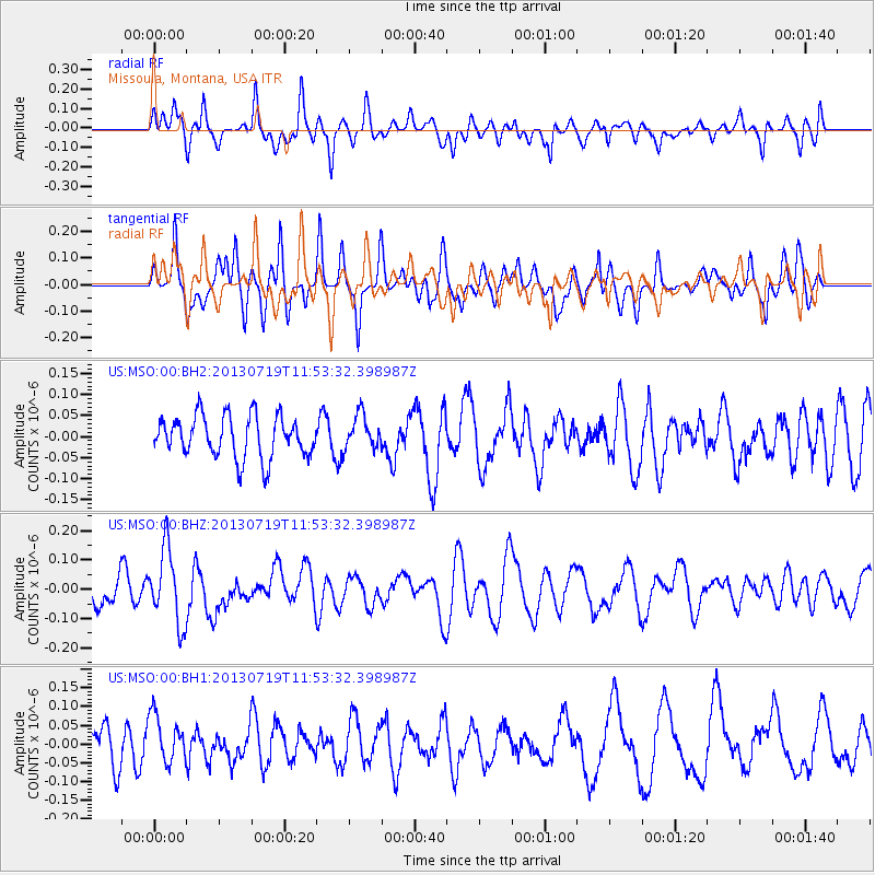
MSO Missoula, Montana, USA - Earthquake Result Viewer
*The percent match for this event was below the threshold and hence no stack was calculated.
| Earthquake location: |
Kermadec Islands Region |
| Earthquake latitude/longitude: |
-30.5/-176.3 |
| Earthquake time(UTC): |
2013/07/19 (200) 11:40:42 GMT |
| Earthquake Depth: |
22 km |
| Earthquake Magnitude: |
5.7 MW, 5.5 MB, 5.7 MW |
| Earthquake Catalog/Contributor: |
NEIC PDE/NEIC PDE-W |
|
| Network: |
US United States National Seismic Network |
| Station: |
MSO Missoula, Montana, USA |
| Lat/Lon: |
46.83 N/113.94 W |
| Elevation: |
1264 m |
|
| Distance: |
95.3 deg |
| Az: |
37.644 deg |
| Baz: |
230.171 deg |
| Ray Param: |
$rayparam |
*The percent match for this event was below the threshold and hence was not used in the summary stack. |
|
| Radial Match: |
53.085777 % |
| Radial Bump: |
400 |
| Transverse Match: |
53.682713 % |
| Transverse Bump: |
363 |
| SOD ConfigId: |
512894 |
| Insert Time: |
2013-09-15 21:39:39.483 +0000 |
| GWidth: |
2.5 |
| Max Bumps: |
400 |
| Tol: |
0.001 |
|
Signal To Noise
| Channel | StoN | STA | LTA |
| US:MSO:00:BHZ:20130719T11:53:32.398987Z | 2.8655329 | 1.2802704E-7 | 4.4678266E-8 |
| US:MSO:00:BH1:20130719T11:53:32.398987Z | 1.2810825 | 6.3114214E-8 | 4.9266315E-8 |
| US:MSO:00:BH2:20130719T11:53:32.398987Z | 0.81520265 | 4.0499312E-8 | 4.9680054E-8 |
| Arrivals |
| Ps | |
| PpPs | |
| PsPs/PpSs | |


