You are here: Home > Network List > TA - USArray Transportable Network (new EarthScope stations) Stations List
> Station E47A Iron Bridge, ON, CAN > Earthquake Result Viewer
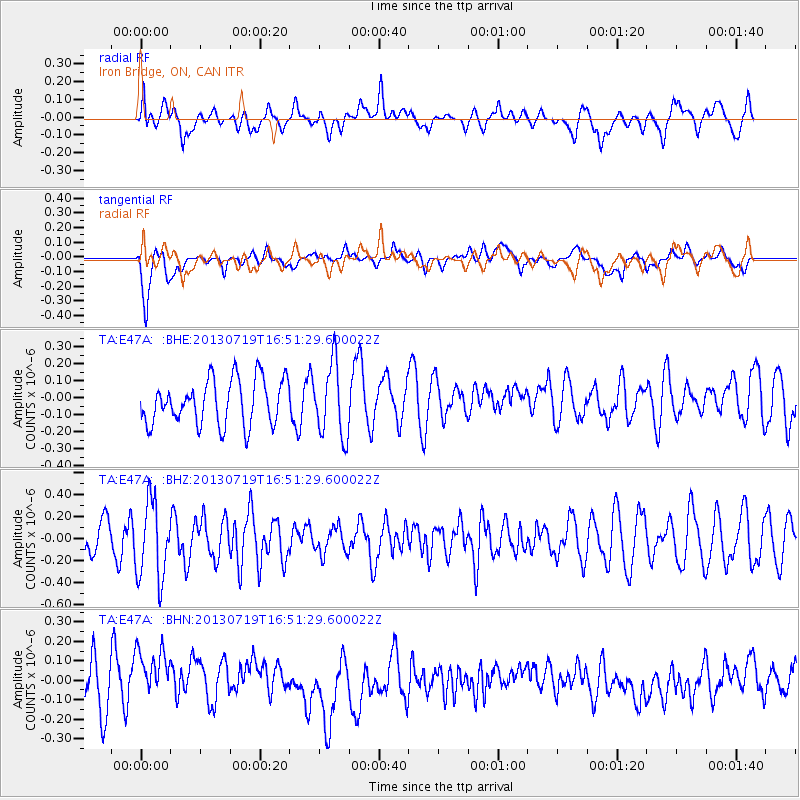
E47A Iron Bridge, ON, CAN - Earthquake Result Viewer
*The percent match for this event was below the threshold and hence no stack was calculated.
| Earthquake location: |
Near East Coast Of Honshu, Japan |
| Earthquake latitude/longitude: |
37.5/141.6 |
| Earthquake time(UTC): |
2013/07/19 (200) 16:39:18 GMT |
| Earthquake Depth: |
40 km |
| Earthquake Magnitude: |
5.5 MW |
| Earthquake Catalog/Contributor: |
NEIC PDE/NEIC PDE-W |
|
| Network: |
TA USArray Transportable Network (new EarthScope stations) |
| Station: |
E47A Iron Bridge, ON, CAN |
| Lat/Lon: |
46.45 N/83.28 W |
| Elevation: |
246 m |
|
| Distance: |
87.2 deg |
| Az: |
29.249 deg |
| Baz: |
325.8 deg |
| Ray Param: |
$rayparam |
*The percent match for this event was below the threshold and hence was not used in the summary stack. |
|
| Radial Match: |
58.341305 % |
| Radial Bump: |
400 |
| Transverse Match: |
77.677536 % |
| Transverse Bump: |
400 |
| SOD ConfigId: |
512894 |
| Insert Time: |
2013-09-15 22:06:52.209 +0000 |
| GWidth: |
2.5 |
| Max Bumps: |
400 |
| Tol: |
0.001 |
|
Signal To Noise
| Channel | StoN | STA | LTA |
| TA:E47A: :BHZ:20130719T16:51:29.600022Z | 2.3880608 | 3.5252887E-7 | 1.4762139E-7 |
| TA:E47A: :BHN:20130719T16:51:29.600022Z | 1.4422317 | 1.7933301E-7 | 1.2434411E-7 |
| TA:E47A: :BHE:20130719T16:51:29.600022Z | 1.610034 | 2.1404385E-7 | 1.3294368E-7 |
| Arrivals |
| Ps | |
| PpPs | |
| PsPs/PpSs | |


