You are here: Home > Network List > TA - USArray Transportable Network (new EarthScope stations) Stations List
> Station E54A Lac Daplat, Pontiac, MRC, QC, CAN > Earthquake Result Viewer
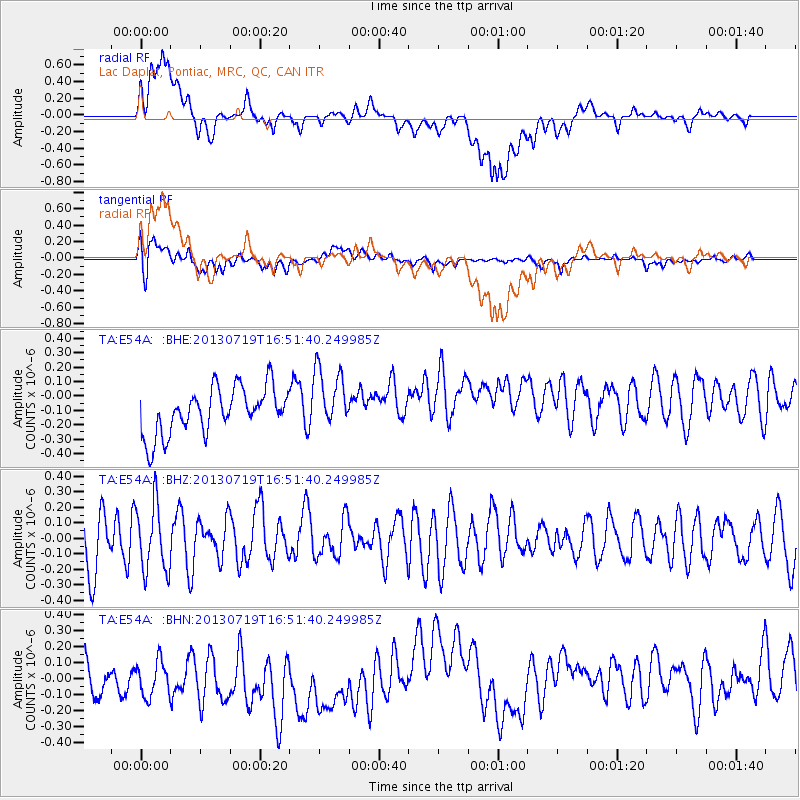
E54A Lac Daplat, Pontiac, MRC, QC, CAN - Earthquake Result Viewer
*The percent match for this event was below the threshold and hence no stack was calculated.
| Earthquake location: |
Near East Coast Of Honshu, Japan |
| Earthquake latitude/longitude: |
37.5/141.6 |
| Earthquake time(UTC): |
2013/07/19 (200) 16:39:18 GMT |
| Earthquake Depth: |
40 km |
| Earthquake Magnitude: |
5.5 MW |
| Earthquake Catalog/Contributor: |
NEIC PDE/NEIC PDE-W |
|
| Network: |
TA USArray Transportable Network (new EarthScope stations) |
| Station: |
E54A Lac Daplat, Pontiac, MRC, QC, CAN |
| Lat/Lon: |
46.43 N/77.19 W |
| Elevation: |
277 m |
|
| Distance: |
89.5 deg |
| Az: |
25.69 deg |
| Baz: |
330.099 deg |
| Ray Param: |
$rayparam |
*The percent match for this event was below the threshold and hence was not used in the summary stack. |
|
| Radial Match: |
42.206608 % |
| Radial Bump: |
400 |
| Transverse Match: |
67.18091 % |
| Transverse Bump: |
400 |
| SOD ConfigId: |
512894 |
| Insert Time: |
2013-09-15 22:07:06.546 +0000 |
| GWidth: |
2.5 |
| Max Bumps: |
400 |
| Tol: |
0.001 |
|
Signal To Noise
| Channel | StoN | STA | LTA |
| TA:E54A: :BHZ:20130719T16:51:40.249985Z | 1.06302 | 2.1605887E-7 | 2.0325005E-7 |
| TA:E54A: :BHN:20130719T16:51:40.249985Z | 0.7872969 | 2.2033609E-7 | 2.7986403E-7 |
| TA:E54A: :BHE:20130719T16:51:40.249985Z | 1.3310347 | 2.1330268E-7 | 1.602533E-7 |
| Arrivals |
| Ps | |
| PpPs | |
| PsPs/PpSs | |


