You are here: Home > Network List > TA - USArray Transportable Network (new EarthScope stations) Stations List
> Station W46A Michie, TN, USA > Earthquake Result Viewer
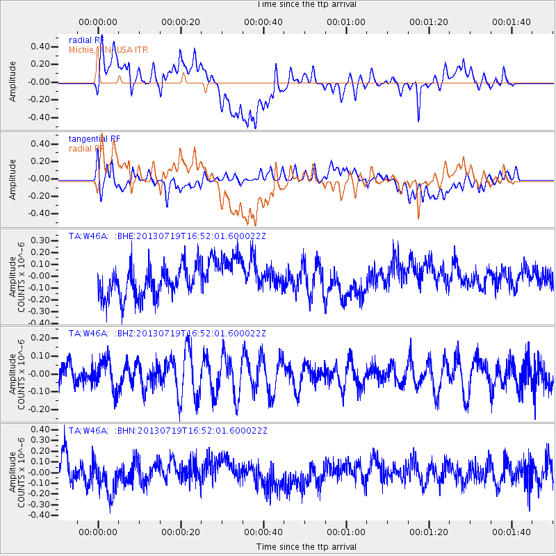
W46A Michie, TN, USA - Earthquake Result Viewer
*The percent match for this event was below the threshold and hence no stack was calculated.
| Earthquake location: |
Near East Coast Of Honshu, Japan |
| Earthquake latitude/longitude: |
37.5/141.6 |
| Earthquake time(UTC): |
2013/07/19 (200) 16:39:18 GMT |
| Earthquake Depth: |
40 km |
| Earthquake Magnitude: |
5.5 MW |
| Earthquake Catalog/Contributor: |
NEIC PDE/NEIC PDE-W |
|
| Network: |
TA USArray Transportable Network (new EarthScope stations) |
| Station: |
W46A Michie, TN, USA |
| Lat/Lon: |
35.13 N/88.38 W |
| Elevation: |
145 m |
|
| Distance: |
94.1 deg |
| Az: |
39.015 deg |
| Baz: |
322.349 deg |
| Ray Param: |
$rayparam |
*The percent match for this event was below the threshold and hence was not used in the summary stack. |
|
| Radial Match: |
45.086452 % |
| Radial Bump: |
400 |
| Transverse Match: |
47.714966 % |
| Transverse Bump: |
400 |
| SOD ConfigId: |
512894 |
| Insert Time: |
2013-09-15 22:14:33.070 +0000 |
| GWidth: |
2.5 |
| Max Bumps: |
400 |
| Tol: |
0.001 |
|
Signal To Noise
| Channel | StoN | STA | LTA |
| TA:W46A: :BHZ:20130719T16:52:01.600022Z | 1.1175874 | 8.747131E-8 | 7.826797E-8 |
| TA:W46A: :BHN:20130719T16:52:01.600022Z | 1.5248066 | 1.6923919E-7 | 1.1099059E-7 |
| TA:W46A: :BHE:20130719T16:52:01.600022Z | 1.6141951 | 2.077623E-7 | 1.2870953E-7 |
| Arrivals |
| Ps | |
| PpPs | |
| PsPs/PpSs | |


