You are here: Home > Network List > TA - USArray Transportable Network (new EarthScope stations) Stations List
> Station J45A Montague, MI, USA > Earthquake Result Viewer
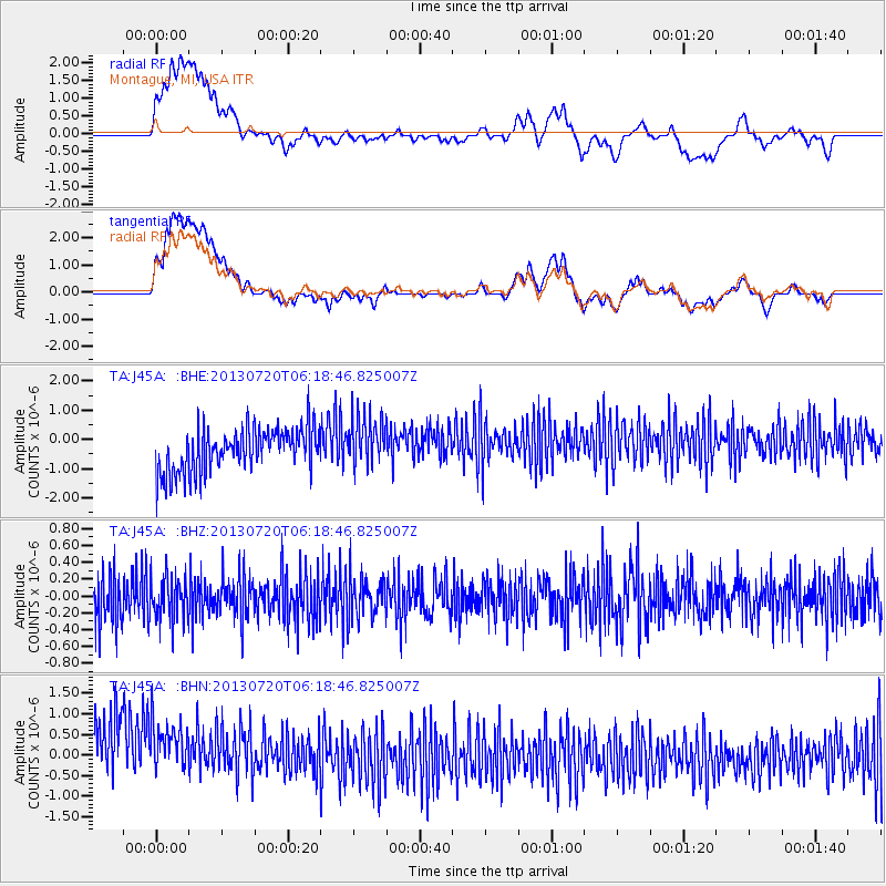
J45A Montague, MI, USA - Earthquake Result Viewer
*The percent match for this event was below the threshold and hence no stack was calculated.
| Earthquake location: |
Near East Coast Of Honshu, Japan |
| Earthquake latitude/longitude: |
36.3/141.7 |
| Earthquake time(UTC): |
2013/07/20 (201) 06:06:22 GMT |
| Earthquake Depth: |
14 km |
| Earthquake Magnitude: |
5.5 MB |
| Earthquake Catalog/Contributor: |
NEIC PDE/NEIC PDE-W |
|
| Network: |
TA USArray Transportable Network (new EarthScope stations) |
| Station: |
J45A Montague, MI, USA |
| Lat/Lon: |
43.44 N/86.39 W |
| Elevation: |
209 m |
|
| Distance: |
89.4 deg |
| Az: |
32.827 deg |
| Baz: |
323.019 deg |
| Ray Param: |
$rayparam |
*The percent match for this event was below the threshold and hence was not used in the summary stack. |
|
| Radial Match: |
16.289783 % |
| Radial Bump: |
400 |
| Transverse Match: |
13.842344 % |
| Transverse Bump: |
400 |
| SOD ConfigId: |
512894 |
| Insert Time: |
2013-09-15 22:44:58.775 +0000 |
| GWidth: |
2.5 |
| Max Bumps: |
400 |
| Tol: |
0.001 |
|
Signal To Noise
| Channel | StoN | STA | LTA |
| TA:J45A: :BHZ:20130720T06:18:46.825007Z | 0.9187235 | 2.4749124E-7 | 2.69386E-7 |
| TA:J45A: :BHN:20130720T06:18:46.825007Z | 0.90524447 | 1.5101266E-6 | 1.6681975E-6 |
| TA:J45A: :BHE:20130720T06:18:46.825007Z | 1.1858679 | 8.974288E-7 | 7.567696E-7 |
| Arrivals |
| Ps | |
| PpPs | |
| PsPs/PpSs | |


