You are here: Home > Network List > TA - USArray Transportable Network (new EarthScope stations) Stations List
> Station P57A Homestead Farm, Martinsburg, WV, USA > Earthquake Result Viewer
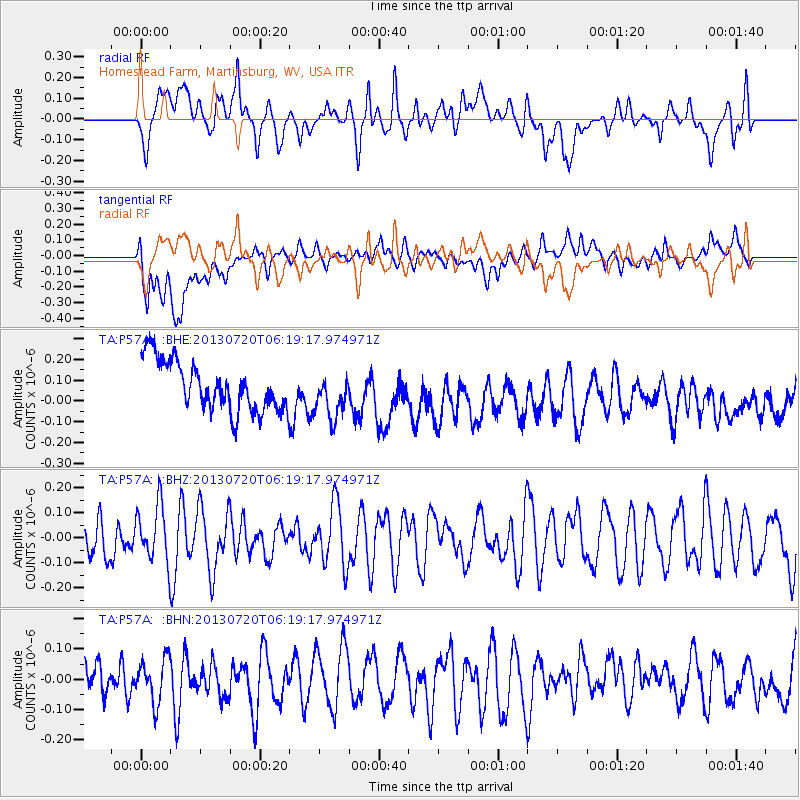
P57A Homestead Farm, Martinsburg, WV, USA - Earthquake Result Viewer
*The percent match for this event was below the threshold and hence no stack was calculated.
| Earthquake location: |
Near East Coast Of Honshu, Japan |
| Earthquake latitude/longitude: |
36.3/141.7 |
| Earthquake time(UTC): |
2013/07/20 (201) 06:06:22 GMT |
| Earthquake Depth: |
14 km |
| Earthquake Magnitude: |
5.5 MB |
| Earthquake Catalog/Contributor: |
NEIC PDE/NEIC PDE-W |
|
| Network: |
TA USArray Transportable Network (new EarthScope stations) |
| Station: |
P57A Homestead Farm, Martinsburg, WV, USA |
| Lat/Lon: |
39.48 N/78.01 W |
| Elevation: |
191 m |
|
| Distance: |
96.2 deg |
| Az: |
29.827 deg |
| Baz: |
328.701 deg |
| Ray Param: |
$rayparam |
*The percent match for this event was below the threshold and hence was not used in the summary stack. |
|
| Radial Match: |
53.673058 % |
| Radial Bump: |
400 |
| Transverse Match: |
54.621826 % |
| Transverse Bump: |
400 |
| SOD ConfigId: |
512894 |
| Insert Time: |
2013-09-15 22:47:55.420 +0000 |
| GWidth: |
2.5 |
| Max Bumps: |
400 |
| Tol: |
0.001 |
|
Signal To Noise
| Channel | StoN | STA | LTA |
| TA:P57A: :BHZ:20130720T06:19:17.974971Z | 0.9967288 | 1.1194606E-7 | 1.1231346E-7 |
| TA:P57A: :BHN:20130720T06:19:17.974971Z | 0.84417963 | 7.161123E-8 | 8.4829374E-8 |
| TA:P57A: :BHE:20130720T06:19:17.974971Z | 0.9282384 | 1.106767E-7 | 1.1923305E-7 |
| Arrivals |
| Ps | |
| PpPs | |
| PsPs/PpSs | |


