You are here: Home > Network List > TA - USArray Transportable Network (new EarthScope stations) Stations List
> Station S49A Springfield, KY, USA > Earthquake Result Viewer
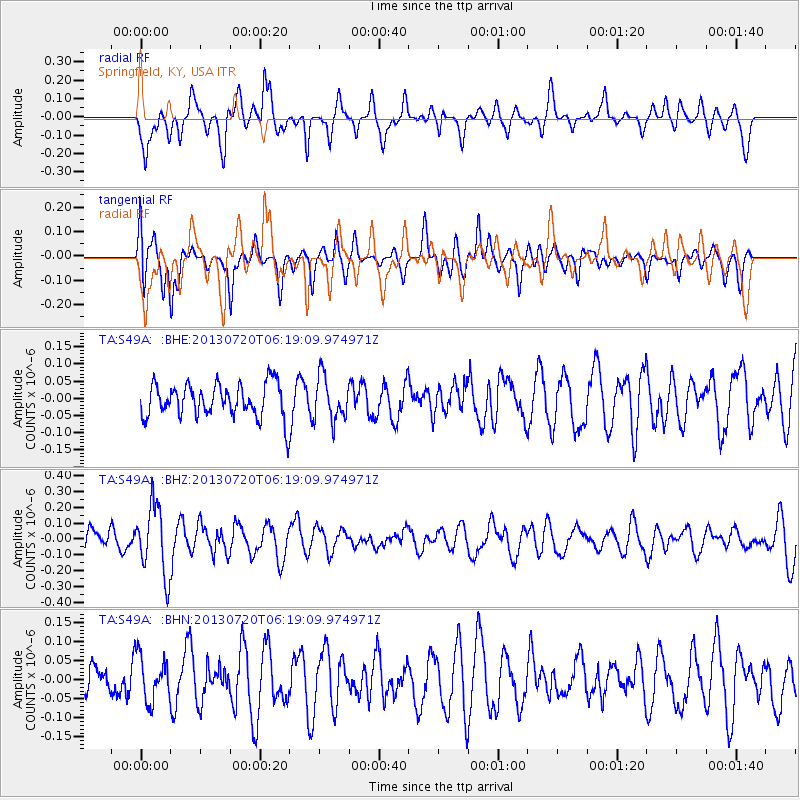
S49A Springfield, KY, USA - Earthquake Result Viewer
*The percent match for this event was below the threshold and hence no stack was calculated.
| Earthquake location: |
Near East Coast Of Honshu, Japan |
| Earthquake latitude/longitude: |
36.3/141.7 |
| Earthquake time(UTC): |
2013/07/20 (201) 06:06:22 GMT |
| Earthquake Depth: |
14 km |
| Earthquake Magnitude: |
5.5 MB |
| Earthquake Catalog/Contributor: |
NEIC PDE/NEIC PDE-W |
|
| Network: |
TA USArray Transportable Network (new EarthScope stations) |
| Station: |
S49A Springfield, KY, USA |
| Lat/Lon: |
37.78 N/85.29 W |
| Elevation: |
230 m |
|
| Distance: |
94.5 deg |
| Az: |
35.526 deg |
| Baz: |
323.643 deg |
| Ray Param: |
$rayparam |
*The percent match for this event was below the threshold and hence was not used in the summary stack. |
|
| Radial Match: |
67.19948 % |
| Radial Bump: |
400 |
| Transverse Match: |
67.631256 % |
| Transverse Bump: |
400 |
| SOD ConfigId: |
512894 |
| Insert Time: |
2013-09-15 22:48:53.616 +0000 |
| GWidth: |
2.5 |
| Max Bumps: |
400 |
| Tol: |
0.001 |
|
Signal To Noise
| Channel | StoN | STA | LTA |
| TA:S49A: :BHZ:20130720T06:19:09.974971Z | 3.0934055 | 2.1729299E-7 | 7.0243935E-8 |
| TA:S49A: :BHN:20130720T06:19:09.974971Z | 1.1824901 | 5.8328624E-8 | 4.9326943E-8 |
| TA:S49A: :BHE:20130720T06:19:09.974971Z | 1.3046163 | 6.4043796E-8 | 4.909014E-8 |
| Arrivals |
| Ps | |
| PpPs | |
| PsPs/PpSs | |


