You are here: Home > Network List > TA - USArray Transportable Network (new EarthScope stations) Stations List
> Station T52A Hallie, KY, USA > Earthquake Result Viewer
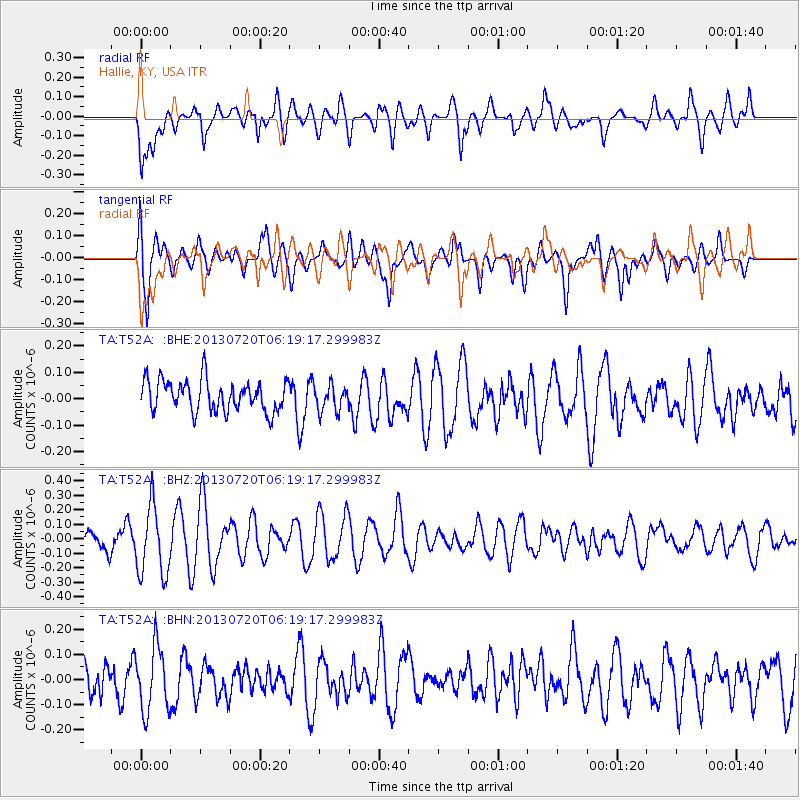
T52A Hallie, KY, USA - Earthquake Result Viewer
*The percent match for this event was below the threshold and hence no stack was calculated.
| Earthquake location: |
Near East Coast Of Honshu, Japan |
| Earthquake latitude/longitude: |
36.3/141.7 |
| Earthquake time(UTC): |
2013/07/20 (201) 06:06:22 GMT |
| Earthquake Depth: |
14 km |
| Earthquake Magnitude: |
5.5 MB |
| Earthquake Catalog/Contributor: |
NEIC PDE/NEIC PDE-W |
|
| Network: |
TA USArray Transportable Network (new EarthScope stations) |
| Station: |
T52A Hallie, KY, USA |
| Lat/Lon: |
37.11 N/82.99 W |
| Elevation: |
436 m |
|
| Distance: |
96.1 deg |
| Az: |
34.425 deg |
| Baz: |
325.138 deg |
| Ray Param: |
$rayparam |
*The percent match for this event was below the threshold and hence was not used in the summary stack. |
|
| Radial Match: |
61.327118 % |
| Radial Bump: |
400 |
| Transverse Match: |
66.1771 % |
| Transverse Bump: |
400 |
| SOD ConfigId: |
512894 |
| Insert Time: |
2013-09-15 22:49:18.519 +0000 |
| GWidth: |
2.5 |
| Max Bumps: |
400 |
| Tol: |
0.001 |
|
Signal To Noise
| Channel | StoN | STA | LTA |
| TA:T52A: :BHZ:20130720T06:19:17.299983Z | 2.4856622 | 2.3912366E-7 | 9.620119E-8 |
| TA:T52A: :BHN:20130720T06:19:17.299983Z | 1.5205231 | 1.2939073E-7 | 8.509619E-8 |
| TA:T52A: :BHE:20130720T06:19:17.299983Z | 0.8457553 | 4.9602328E-8 | 5.864856E-8 |
| Arrivals |
| Ps | |
| PpPs | |
| PsPs/PpSs | |


