You are here: Home > Network List > TA - USArray Transportable Network (new EarthScope stations) Stations List
> Station W52A Murphy, NC, USA > Earthquake Result Viewer
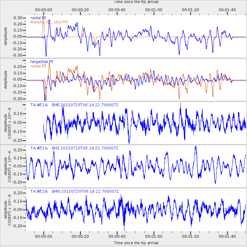
W52A Murphy, NC, USA - Earthquake Result Viewer
*The percent match for this event was below the threshold and hence no stack was calculated.
| Earthquake location: |
Near East Coast Of Honshu, Japan |
| Earthquake latitude/longitude: |
36.3/141.7 |
| Earthquake time(UTC): |
2013/07/20 (201) 06:06:22 GMT |
| Earthquake Depth: |
14 km |
| Earthquake Magnitude: |
5.5 MB |
| Earthquake Catalog/Contributor: |
NEIC PDE/NEIC PDE-W |
|
| Network: |
TA USArray Transportable Network (new EarthScope stations) |
| Station: |
W52A Murphy, NC, USA |
| Lat/Lon: |
35.09 N/83.93 W |
| Elevation: |
519 m |
|
| Distance: |
97.3 deg |
| Az: |
36.221 deg |
| Baz: |
324.376 deg |
| Ray Param: |
$rayparam |
*The percent match for this event was below the threshold and hence was not used in the summary stack. |
|
| Radial Match: |
50.95168 % |
| Radial Bump: |
400 |
| Transverse Match: |
44.68737 % |
| Transverse Bump: |
400 |
| SOD ConfigId: |
512894 |
| Insert Time: |
2013-09-15 22:50:25.275 +0000 |
| GWidth: |
2.5 |
| Max Bumps: |
400 |
| Tol: |
0.001 |
|
Signal To Noise
| Channel | StoN | STA | LTA |
| TA:W52A: :BHZ:20130720T06:19:22.700007Z | 0.73840505 | 6.997394E-8 | 9.476362E-8 |
| TA:W52A: :BHN:20130720T06:19:22.700007Z | 0.85100067 | 7.236725E-8 | 8.503783E-8 |
| TA:W52A: :BHE:20130720T06:19:22.700007Z | 0.7450149 | 5.1880708E-8 | 6.963714E-8 |
| Arrivals |
| Ps | |
| PpPs | |
| PsPs/PpSs | |


